IMAGES TAKEN NEAR TO
Carnegie Avenue, LIVERPOOL, L23 3BR
Introduction
This page details the photographs taken nearby to Carnegie Avenue, L23 3BR by members of the Geograph project.
The Geograph project started in 2005 with the aim of publishing, organising and preserving representative images for every square kilometre of Great Britain, Ireland and the Isle of Man.

There are currently over 7.5m images from over14,400 individuals and you can help contribute to the project by visiting https://www.geograph.org.uk
Image Map
Images are licensed for reuse under creativecommons.org/licenses/by-sa/2.0
Notes
- Clicking on the map will re-center to the selected point.
- The higher the marker number, the further away the image location is from the centre of the postcode.
Image Listing (48 Images Found)
Images are licensed for reuse under creativecommons.org/licenses/by-sa/2.0
Image
Details
Distance
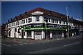
1
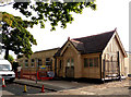
A new restaurant is to open in Carnegie Road
Image: © Norman Caesar
Taken: 19 Sep 2015
0.01 miles
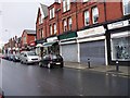
2
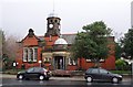
Carnegie Library, College Road
On 6th December 2013 this library closed for business
Image: © Norman Caesar
Taken: 4 Dec 2011
0.01 miles
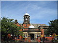
6
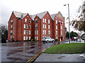
Apartments
Apartments built on the site of Alexandra Hall, the old Administrative centre for Crosby.
Image: © Norman Caesar
Taken: 17 Dec 2011
0.04 miles
8
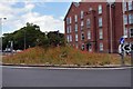
Poppy island
This island, covered in poppies is at the end of College Road
Image: © Norman Caesar
Taken: 3 Jun 2019
0.05 miles
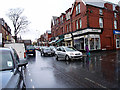
9
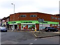
Co-operative food store, College Road
Image: © Norman Caesar
Taken: 16 Jul 2016
0.06 miles