IMAGES TAKEN NEAR TO
Moor Drive, LIVERPOOL, L23 2UR
Introduction
This page details the photographs taken nearby to Moor Drive, L23 2UR by members of the Geograph project.
The Geograph project started in 2005 with the aim of publishing, organising and preserving representative images for every square kilometre of Great Britain, Ireland and the Isle of Man.

There are currently over 7.5m images from over14,400 individuals and you can help contribute to the project by visiting https://www.geograph.org.uk
Image Map
Images are licensed for reuse under creativecommons.org/licenses/by-sa/2.0
Notes
- Clicking on the map will re-center to the selected point.
- The higher the marker number, the further away the image location is from the centre of the postcode.
Image Listing (40 Images Found)
Images are licensed for reuse under creativecommons.org/licenses/by-sa/2.0
Image
Details
Distance
1
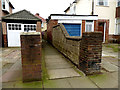
Passage
This passage is shown on O.S.1907 map as a footpath
Image: © Norman Caesar
Taken: 12 Mar 2015
0.09 miles
2

Floral display outside a private house
Image: © Norman Caesar
Taken: 18 Jul 2016
0.14 miles
3
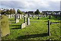
St Luke's churchyard, Great Crosby
This is very large for a churchyard.
Image: © Bill Boaden
Taken: 25 Oct 2014
0.14 miles
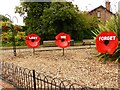
5
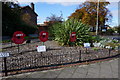
WWI memorial garden in Great Crosby
The garden includes poetry and a sculpture of gassed troops returning from the front.
Image: © Bill Boaden
Taken: 25 Oct 2014
0.16 miles
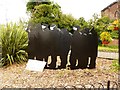
6
Sculpture commemorating WW1 centenary
Image: © Norman Caesar
Taken: 18 Jul 2014
0.16 miles
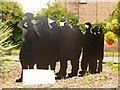
7
Sculpture commemorating WW1 centenary
Image: © Norman Caesar
Taken: 18 Jul 2014
0.16 miles

9
Sculpture commemorating WW1 centenary
Image: © Norman Caesar
Taken: 18 Jul 2014
0.16 miles
10

Sculpture commemorating WW1 centenary
Image: © Norman Caesar
Taken: 18 Jul 2014
0.17 miles