IMAGES TAKEN NEAR TO
Stannyfield Close, LIVERPOOL, L23 1ZA
Introduction
This page details the photographs taken nearby to Stannyfield Close, L23 1ZA by members of the Geograph project.
The Geograph project started in 2005 with the aim of publishing, organising and preserving representative images for every square kilometre of Great Britain, Ireland and the Isle of Man.

There are currently over 7.5m images from over14,400 individuals and you can help contribute to the project by visiting https://www.geograph.org.uk
Image Map
Images are licensed for reuse under creativecommons.org/licenses/by-sa/2.0
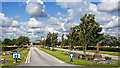
Notes
- Clicking on the map will re-center to the selected point.
- The higher the marker number, the further away the image location is from the centre of the postcode.
Image Listing (25 Images Found)
Images are licensed for reuse under creativecommons.org/licenses/by-sa/2.0
Image
Details
Distance
1
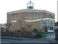
St William of York
Locally known as the Thrupenny-bit church
Image: © Peter Hodge
Taken: 24 Dec 2005
0.13 miles
5
St Frideswyde church, Thornton
Architects Bruxby & Evans, 1961. The church was demolished in 2011.
Image: © S Parish
Taken: Unknown
0.20 miles
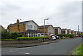
7
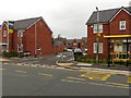
New housing
This new housing estate has been built on the site of the now demolished St. Frideswyde's Church
Image: © Norman Caesar
Taken: 13 Oct 2013
0.20 miles
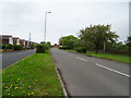
8
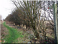
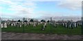
Rakes Lane
Rakes Lane, a byway alongside Thornton Cemetery.
Image: © Norman Caesar
Taken: 21 Jan 2012
0.21 miles
9
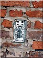
Flush Bracket
This flush bracket is on the wall of Lydiate Farm Rothwell Lane
Image: © Norman Caesar
Taken: 26 Feb 2014
0.22 miles