IMAGES TAKEN NEAR TO
Strathmore Drive, LIVERPOOL, L23 0RB
Introduction
This page details the photographs taken nearby to Strathmore Drive, L23 0RB by members of the Geograph project.
The Geograph project started in 2005 with the aim of publishing, organising and preserving representative images for every square kilometre of Great Britain, Ireland and the Isle of Man.

There are currently over 7.5m images from over14,400 individuals and you can help contribute to the project by visiting https://www.geograph.org.uk
Image Map
Images are licensed for reuse under creativecommons.org/licenses/by-sa/2.0
Notes
- Clicking on the map will re-center to the selected point.
- The higher the marker number, the further away the image location is from the centre of the postcode.
Image Listing (18 Images Found)
Images are licensed for reuse under creativecommons.org/licenses/by-sa/2.0
Image
Details
Distance
2

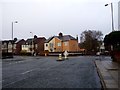
School being used as a EU referendum polling station
Image: © Norman Caesar
Taken: 23 Jun 2016
0.10 miles
3

School being used as a EU referendum polling station
Image: © Norman Caesar
Taken: 23 Jun 2016
0.12 miles
4
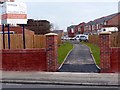
Entrance to Hawthorn Park Estate
This is the pedestrian entrance to Hawthorn Park Estate see SJ 3299 New housing estate on South Parade for the main entrance
Image: © Norman Caesar
Taken: 28 Feb 2015
0.13 miles
5
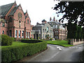
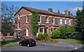
Nazareth House From the Main Road Entrance
Image: © Robert Brown
Taken: 16 Sep 2007
0.14 miles
6
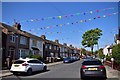
Street decorations to celebrate the 75th anniversary of VE day
Image: © Norman Caesar
Taken: 7 May 2020
0.15 miles
7
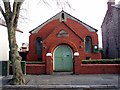
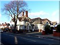
Bethel Church
This is an Independent Evangelical Church
Image: © Norman Caesar
Taken: 13 Feb 2012
0.18 miles
8
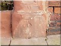
O.S. Benchmark
This benchmark is on a gatepost near SS Peter and Paul's church
Image: © Norman Caesar
Taken: 15 Jan 2015
0.19 miles
9
Fancy brickwork on Liverpool Road, Great Crosby
Image: © Raymond Knapman
Taken: 8 Aug 2012
0.20 miles
10
Junction of 5 Roads
Junction of Stuart Rd, Endbutt Lane, Brownmore Lane,
Derwent Rd.and Dorbett Drive.
Image: © Norman Caesar
Taken: 21 Nov 2011
0.21 miles