IMAGES TAKEN NEAR TO
Church Road, LIVERPOOL, L21 7LE
Introduction
This page details the photographs taken nearby to Church Road, L21 7LE by members of the Geograph project.
The Geograph project started in 2005 with the aim of publishing, organising and preserving representative images for every square kilometre of Great Britain, Ireland and the Isle of Man.

There are currently over 7.5m images from over14,400 individuals and you can help contribute to the project by visiting https://www.geograph.org.uk
Image Map
Images are licensed for reuse under creativecommons.org/licenses/by-sa/2.0
Notes
- Clicking on the map will re-center to the selected point.
- The higher the marker number, the further away the image location is from the centre of the postcode.
Image Listing (38 Images Found)
Images are licensed for reuse under creativecommons.org/licenses/by-sa/2.0
Image
Details
Distance
1
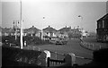
Sefton Road Roundabout, 1955
The roundabout at the junction of Sefton and Hawthorn Roads in 1955. Not the best quality image but it has some interesting items. Note the old gas lamp and the old 'keep left' signs still in position on the island, the pre-fabs on the far corner, these lasted until at least the 1970's, The Regal cinema can be seen in the distance. I am no expert on old cars but I think this may have been a Morris Oxford. Another view Image]
Image: © Gordon Cragg
Taken: Unknown
0.08 miles
2
Sefton Road Roundabout & Hawthorne Court
Roundabout at the junction of Sefton Road and Hawthorne Road. Hawthorne Court is purpose built assisted housing for the elderly behind which stood Litherland Park Wesleyan Methodist Church which was demolished in 2004.
Image: © Sue Adair
Taken: 13 Aug 2009
0.08 miles
3
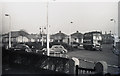
Sefton Road Roundabout, 1955
Another view of the roundabout at the junction of Sefton and Hawthorn Roads in 1955. Not the best quality image but it has some interesting items. Note the pre-fabs on the far corner, these lasted until at least the 1970's, The Regal cinema can be seen in the distance and the steeple of St Phillip's Church is peeking under gas lamp. The Leyland Ribble bus is on the 55 route from Ford to Liverpool city centre. Not sure about the cars, but I think that one could be a Standard Vanguard and the other an Armstrong Siddeley. Please correct me if I am wrong. Another view Image]
Image: © Gordon Cragg
Taken: Unknown
0.09 miles
4
English Martyrs Roman Catholic Church, Litherland
On School Lane.
Image: © JThomas
Taken: 28 Apr 2019
0.10 miles
5
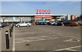
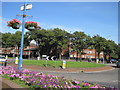
Tesco Superstore, Litherland
Frosty morning view across the Tesco car park at their large Litherland store.
Image: © Rude Health
Taken: 28 Feb 2013
0.13 miles
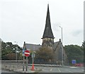
6
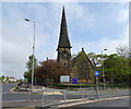
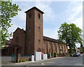
St Philip's Church, Litherland
Opened in 1863.
Image: © JThomas
Taken: 28 Apr 2019
0.13 miles
8
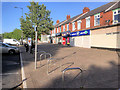
Sefton Road Shops
Row of shops on Sefton Road, Litherland.
Image: © David Dixon
Taken: 8 May 2017
0.14 miles
9
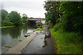
Leeds & Liverpool Canal
At bridge 2j, Litherland Bridges.
Image: © Ian S
Taken: 11 Jun 2019
0.14 miles
10
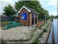
Boaters' facilities, Litherland
Toilets, water point, secure moorings, rubbish bins and self-use toilet pump out, all in a gated compound next to a Tesco superstore.
Image: © Christine Johnstone
Taken: 25 May 2021
0.14 miles