IMAGES TAKEN NEAR TO
Arnside, LIVERPOOL, L21 5JH
Introduction
This page details the photographs taken nearby to Arnside, L21 5JH by members of the Geograph project.
The Geograph project started in 2005 with the aim of publishing, organising and preserving representative images for every square kilometre of Great Britain, Ireland and the Isle of Man.

There are currently over 7.5m images from over14,400 individuals and you can help contribute to the project by visiting https://www.geograph.org.uk
Image Map
Images are licensed for reuse under creativecommons.org/licenses/by-sa/2.0
Notes
- Clicking on the map will re-center to the selected point.
- The higher the marker number, the further away the image location is from the centre of the postcode.
Image Listing (10 Images Found)
Images are licensed for reuse under creativecommons.org/licenses/by-sa/2.0
Image
Details
Distance
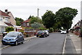
4
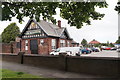
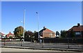
The Netherton Public House, Litherland
Image: © Mike Pennington
Taken: 8 Jul 2016
0.14 miles
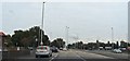
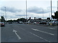
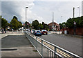
7
Junction of the A5036 and the A5038, Bootle
Dunnings Bridge Lane to the left, Church Road to the right, Netherton Way behind and Boundary Road ahead.
Image: © Mike Pennington
Taken: 8 Jul 2016
0.18 miles
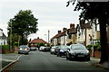
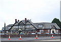
8
The junction of Church Road with Kirkstone Road
Kirkstone Road South goes off to the right.
Image: © Jonathan Thacker
Taken: 29 Sep 2018
0.18 miles
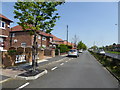
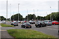
9
The traffic lights at Kirkstone Road North
Image: © Ian Greig
Taken: 2 Aug 2014
0.18 miles