IMAGES TAKEN NEAR TO
Church Road, LIVERPOOL, L21 5HA
Introduction
This page details the photographs taken nearby to Church Road, L21 5HA by members of the Geograph project.
The Geograph project started in 2005 with the aim of publishing, organising and preserving representative images for every square kilometre of Great Britain, Ireland and the Isle of Man.

There are currently over 7.5m images from over14,400 individuals and you can help contribute to the project by visiting https://www.geograph.org.uk
Image Map
Images are licensed for reuse under creativecommons.org/licenses/by-sa/2.0
Notes
- Clicking on the map will re-center to the selected point.
- The higher the marker number, the further away the image location is from the centre of the postcode.
Image Listing (7 Images Found)
Images are licensed for reuse under creativecommons.org/licenses/by-sa/2.0
Image
Details
Distance
2
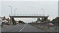
The traffic lights at Kirkstone Road North
Image: © Ian Greig
Taken: 2 Aug 2014
0.15 miles
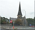
3
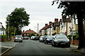
The junction of Church Road with Kirkstone Road
Kirkstone Road South goes off to the right.
Image: © Jonathan Thacker
Taken: 29 Sep 2018
0.15 miles
4
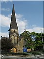
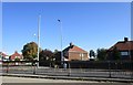
St Philip's, Litherland
A group of local businessmen financed the church which was built on land donated by The Earl of Sefton and was named St Philip in recognition of his generous gesture. Built of sandstone from a local quarry it was opened in 1863.
Image: © Sue Adair
Taken: 24 May 2008
0.19 miles
6
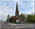
St Philip's Church, Litherland
Opened in 1863.
Image: © JThomas
Taken: 28 Apr 2019
0.22 miles