IMAGES TAKEN NEAR TO
Montgomery Close, L21 1ET
Introduction
This page details the photographs taken nearby to Montgomery Close, L21 1ET by members of the Geograph project.
The Geograph project started in 2005 with the aim of publishing, organising and preserving representative images for every square kilometre of Great Britain, Ireland and the Isle of Man.

There are currently over 7.5m images from over14,400 individuals and you can help contribute to the project by visiting https://www.geograph.org.uk
Image Map
Images are licensed for reuse under creativecommons.org/licenses/by-sa/2.0
Notes
- Clicking on the map will re-center to the selected point.
- The higher the marker number, the further away the image location is from the centre of the postcode.
Image Listing (13 Images Found)
Images are licensed for reuse under creativecommons.org/licenses/by-sa/2.0
Image
Details
Distance
1
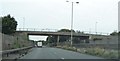
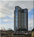
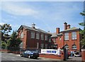
National Grid roadworks on the B5421
The high-rise building behind the van is Alexander House
Image: © Eirian Evans
Taken: 9 May 2016
0.04 miles
2
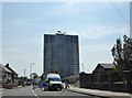
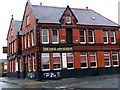
Montgomery House
3 attempts were made to demolish Montgomery House by explosion but all it did was lean over. This machine has now been brought in to take the building down floor by floor
Image: © Norman Caesar
Taken: 1 May 2016
0.04 miles
3
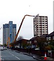
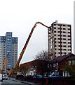
Montgomery House
3 attempts were made to demolish Montgomery House by explosion but all it did was lean over. This machine has now been brought in to take the building down floor by floor
Image: © Norman Caesar
Taken: 1 May 2016
0.05 miles
5
In memory of Seaforth Barracks
Seaforth Barracks were opened in 1882 as a cavalry barracks with accommodation for over 200 men and 80 horses and closed in 1958. It is now a housing estate.
Image: © Norman Caesar
Taken: 27 Apr 2012
0.11 miles
9
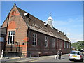
William Gladstone Church of England Primary School
The former William Gladstone Church of England Primary School in Thomson Road, Seaforth. The pupils have now joined children from Beach Road in a brand new school named Rimrose Hope. This school has now been demolished (Jan 2010).
William Gladstone was educated at a preparatory school at Seaforth Vicarage before attending Eton between 1821 and 1827.
Image: © Sue Adair
Taken: 13 Aug 2009
0.21 miles