IMAGES TAKEN NEAR TO
Edith Villas, Fernhill Road, BOOTLE, L20 9HT
Introduction
This page details the photographs taken nearby to Edith Villas, Fernhill Road, L20 9HT by members of the Geograph project.
The Geograph project started in 2005 with the aim of publishing, organising and preserving representative images for every square kilometre of Great Britain, Ireland and the Isle of Man.

There are currently over 7.5m images from over14,400 individuals and you can help contribute to the project by visiting https://www.geograph.org.uk
Image Map
Images are licensed for reuse under creativecommons.org/licenses/by-sa/2.0
Notes
- Clicking on the map will re-center to the selected point.
- The higher the marker number, the further away the image location is from the centre of the postcode.
Image Listing (4 Images Found)
Images are licensed for reuse under creativecommons.org/licenses/by-sa/2.0
Image
Details
Distance
1

Church of St Monica, Fernhill Road
St Monica's Rc church in Fernhill Road was completed in 1936. A Grade II listed building in art deco style designed by the architect Francis Xavier Velarde.
Image: © Sue Adair
Taken: 9 Aug 2009
0.11 miles
2
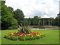
Bandstand, Derby Park
Derby Park was opened in 1895 on land given to the people of Bootle by Lord Derby, a typical example of an urban Victorian park with formal gardens, bandstand and lake (now children's play area). Recently renovated, this attractive little park is largely unknown other than by local residents.
Image: © Sue Adair
Taken: 9 Aug 2009
0.23 miles
3
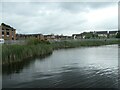
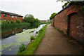
Winding hole, between bridges 2C and 2B
Near Brookhill Road, Bootle.
Image: © Christine Johnstone
Taken: 26 May 2021
0.24 miles