IMAGES TAKEN NEAR TO
Derby Road, LIVERPOOL, L20 8EE
Introduction
This page details the photographs taken nearby to Derby Road, L20 8EE by members of the Geograph project.
The Geograph project started in 2005 with the aim of publishing, organising and preserving representative images for every square kilometre of Great Britain, Ireland and the Isle of Man.

There are currently over 7.5m images from over14,400 individuals and you can help contribute to the project by visiting https://www.geograph.org.uk
Image Map
Images are licensed for reuse under creativecommons.org/licenses/by-sa/2.0
Notes
- Clicking on the map will re-center to the selected point.
- The higher the marker number, the further away the image location is from the centre of the postcode.
Image Listing (33 Images Found)
Images are licensed for reuse under creativecommons.org/licenses/by-sa/2.0
Image
Details
Distance
1
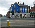
Former pub, Derby Road, Bootle (2)
Derelict pubs in Liverpool seem to reach more exalted states of dereliction than derelict pubs in other places. The Elm House is perhaps the paramount example. It closed before 2008 and retained its upper storeys until 2015/16 (at a guess they were destroyed by fire). Surprisingly, most of what is seen here was still there in 2023. Only the front wall and the left-hand side wall survive.
Image: © Stephen Richards
Taken: 13 Jul 2016
0.01 miles
2
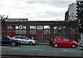
Harland & Wolff old Foundry entrance, Strand Road, Bootle
The foundry was part of Harland & Wolff marine refit and repair shop located on Strand Road, Bootle. Located close to the then entrance to the Alexandra Dock on Regent Road (known locally as the 'Dock Road') The repair shop and foundry no longer exist. The original entrance gate to the Alexandra Dock has long gone. This section of the Dock Road was closed off to the public, the route of the road refigured, and a new entrance to this part of the North Liverpool dock system, which is now called 'The Liverpool Freeport'. Another part of old Liverpool gone for ever! For another view see http://www.geograph.org.uk/photo/1443502.
Image: © david lawler
Taken: 24 Jul 2009
0.05 miles
3

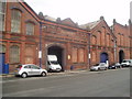
Former Harland & Wolff marine workshop and foundry, Strand Road, Bootle, Liverpool
Another view of the building previously featured http://www.geograph.org.uk/photo/1442125 . Another historic link with Liverpool's great maritime history. The facade of the building appears to be in keeping with the Victorians' desire to build temples to trade and commerce too! Another worthy example that merits preservation. English Heritage please note!
Image: © david lawler
Taken: 24 Jul 2009
0.05 miles
5
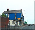
Former pub, Derby Road, Bootle (1)
Formerly the Talbot. Given its proximity to the docks (seen down Church Street) its clientele must have been dock workers and seamen.
It closed before 2008 and in 2023 was still derelict.
Image: © Stephen Richards
Taken: 13 Jul 2016
0.07 miles
6
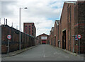
Baltic Road, Bootle
Low-rise sheds and the remains perhaps of something that was once larger on the left. A tall thin warehouse survives at the end on Atlantic Road.
Image: © Stephen Richards
Taken: 13 Jul 2016
0.07 miles
7
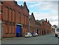
Former warehouses, Strand Road, Bootle
A good run of late C19th buildings, quite ornate, bearing the name of the famous shipbuilders, Harland & Wolff. The middle of the three buildings was a foundry. Grade II listed.
Now entirely a self-storage facility operated by Storage King, but at the time at least partly occupied by Intelligent Engineering Ltd.
Image: © Stephen Richards
Taken: 13 Jul 2016
0.08 miles
8
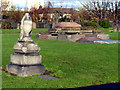
Stone work in church grounds
The parish church of St. Mary stood in these grounds until destroyed by enemy action in 1941
Image: © Norman Caesar
Taken: 14 Nov 2014
0.09 miles
9
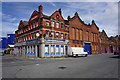
Rubber Duck
Formerly the Higson's pub, the Strand Hotel. Next door on the right is the site of the Liverpool operation of Harland & Wolff, the renowned Belfast shipbuilders who built the Titanic.
Image: © Bill Boaden
Taken: 13 Aug 2016
0.09 miles
10
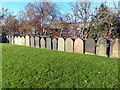
Grave headstones
These grave headstones have been placed at the edge of the grounds were the parish church of St. Mary stood until destroyed by enemy action in 1941
Image: © Norman Caesar
Taken: 14 Nov 2014
0.09 miles