IMAGES TAKEN NEAR TO
Derby Road, LIVERPOOL, L20 8ED
Introduction
This page details the photographs taken nearby to Derby Road, L20 8ED by members of the Geograph project.
The Geograph project started in 2005 with the aim of publishing, organising and preserving representative images for every square kilometre of Great Britain, Ireland and the Isle of Man.

There are currently over 7.5m images from over14,400 individuals and you can help contribute to the project by visiting https://www.geograph.org.uk
Image Map
Images are licensed for reuse under creativecommons.org/licenses/by-sa/2.0
Notes
- Clicking on the map will re-center to the selected point.
- The higher the marker number, the further away the image location is from the centre of the postcode.
Image Listing (46 Images Found)
Images are licensed for reuse under creativecommons.org/licenses/by-sa/2.0
Image
Details
Distance
1
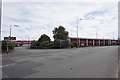
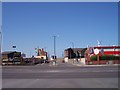
Sandon Estate
A relatively new trading estate compared with its surroundings, built on land linked to Sandon Dock.
Image: © Bill Boaden
Taken: 13 Aug 2016
0.09 miles
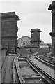
2
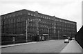
Sandon Dock Goods Station ? 1964
This was the Midland Railway's main goods transfer facility in the northern Liverpool docks, built in the late 1890s. Access was gained via the Cheshire Lines system at Huskisson Station, of which the Midland Railway had joint ownership.
Image: © Alan Murray-Rust
Taken: 29 Jun 1964
0.09 miles
3
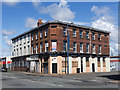
Boundary Street, Liverpool
The junction of Boundary Street and Regent Road in Liverpool's docklands.
Image: © William Starkey
Taken: 23 Aug 2014
0.11 miles
4
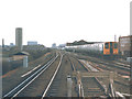
Railway south of Sandhills station
A train to Southport approaching Sandhills station.
Image: © Stephen Craven
Taken: 26 Mar 1988
0.11 miles
5
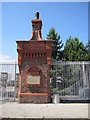
Original Gate, Sandon Dock
Sandon Dock was designed by Jesse Hartley and opened in 1851 connecting directly to the Mersey via a narrow lock entrance which was sealed in 1977. It is now a wastewater treatment plant.
Image: © Sue Adair
Taken: 7 Aug 2009
0.12 miles
6
Part of Liverpool Wastewater Treatment Works
Necessarily quite a big plant.
Image: © Bill Boaden
Taken: 13 Aug 2016
0.12 miles
7
High Level Coal Railway, Liverpool North Docks ? 1964
The lifting bridge carrying the line onto the bunkering staithes across Regent Road. See http://www.geograph.org.uk/photo/6497695 for more details of the High Level Coal Railway.
Image: © Alan Murray-Rust
Taken: 13 Jun 1964
0.15 miles
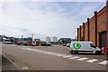
8
Connect Business Village beside Sandhills Station
Image: © Mike Pennington
Taken: 21 Oct 2015
0.16 miles
9
Derby Road crosses Boundary Street
View towards the dock road
Image: © Raymond Knapman
Taken: 28 Apr 2011
0.16 miles
10
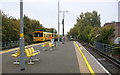
Train leaving Sandhills Station
The train from Kirkby heading for Liverpool Central.
Image: © Mike Pennington
Taken: 21 Oct 2015
0.17 miles