IMAGES TAKEN NEAR TO
Smollett Street, BOOTLE, L20 4PT
Introduction
This page details the photographs taken nearby to Smollett Street, L20 4PT by members of the Geograph project.
The Geograph project started in 2005 with the aim of publishing, organising and preserving representative images for every square kilometre of Great Britain, Ireland and the Isle of Man.

There are currently over 7.5m images from over14,400 individuals and you can help contribute to the project by visiting https://www.geograph.org.uk
Image Map
Images are licensed for reuse under creativecommons.org/licenses/by-sa/2.0
Notes
- Clicking on the map will re-center to the selected point.
- The higher the marker number, the further away the image location is from the centre of the postcode.
Image Listing (19 Images Found)
Images are licensed for reuse under creativecommons.org/licenses/by-sa/2.0
Image
Details
Distance
1

Wesleyan Sunday School, dated 1914, Linacre Road
Interesting detail on windows with leaded lights on the former Wesleyan Sunday School, dated 1914, situated next to the Methodist Mission in Linacre Road. More info and history http://www.linacre.org.uk/history.htm
Image: © Sue Adair
Taken: 14 Jan 2006
0.03 miles
2
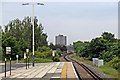
Bridge, Seaforth and Litherland Railway Station
The bridge, which carries the North Mersey Branch railway line, between Bootle and Aintree, is disused. Viewed from the end of the platform at Seaforth and Litherland station, looking south. In the distance, the tower block is the Triad Building on Stanley Road, in Bootle.
Image: © El Pollock
Taken: 13 Jun 2012
0.09 miles
4
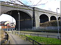
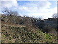
Railway viaduct at Seaforth
The viaduct carries a disused freight line over the Liverpool to Southport electric line.
Image: © Raymond Knapman
Taken: 21 Feb 2014
0.11 miles
5
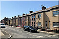
Bowles Street
Uniform houses which appear to have been refurbished by the same housing provider.
Image: © Bill Boaden
Taken: 13 Aug 2016
0.11 miles
6
Bankhall Mission Church
Bankhall Mission Church in Knowsley Road.
Image: © Sue Adair
Taken: 13 Aug 2009
0.14 miles
7
Railway viaduct at Seaforth,view from embankment of dismantled railway
The furthest span carries the track over the Liverpool to Southport lines seen on the right
Image: © Raymond Knapman
Taken: 21 Feb 2014
0.16 miles

9

Empty car dealership
The building on the left is due for demolition.
Image: © Bill Boaden
Taken: 13 Aug 2016
0.17 miles
10

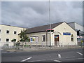
Our Lady Star of the Sea RC Primary School
Image: © Chris Morgan
Taken: 2 Feb 2023
0.21 miles