IMAGES TAKEN NEAR TO
Hawthorne Road, BOOTLE, L20 3AW
Introduction
This page details the photographs taken nearby to Hawthorne Road, L20 3AW by members of the Geograph project.
The Geograph project started in 2005 with the aim of publishing, organising and preserving representative images for every square kilometre of Great Britain, Ireland and the Isle of Man.

There are currently over 7.5m images from over14,400 individuals and you can help contribute to the project by visiting https://www.geograph.org.uk
Image Map
Images are licensed for reuse under creativecommons.org/licenses/by-sa/2.0
Notes
- Clicking on the map will re-center to the selected point.
- The higher the marker number, the further away the image location is from the centre of the postcode.
Image Listing (16 Images Found)
Images are licensed for reuse under creativecommons.org/licenses/by-sa/2.0
Image
Details
Distance
1
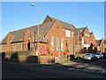
Christ Church School Park Street
Former Christ Church School on the corner corner of Hawthorne Road and Park Road, built in the second half of the 19th Century. It is now a YMCA used for community groups including drama, youth & junior clubs, Beavers, Cubs, Scouts and Venture Scouts.
Image: © Sue Adair
Taken: 3 Jan 2020
0.05 miles
2
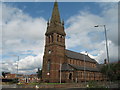
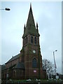
Christ Church, Bootle
Christ Church was built in 1866 by P J Mather of Bootle Hall as a memorial to his daughter. Faced in red sandstone, which probably came from Woolton quarry the same source as Liverpool Cathedral. The eight bronze bells previously hung in Emmanuel Church, Everton, prior to its demolition in 1972. The six steel bells originally hung in the tower are now in St Mary's, Hale near Liverpool airport.
Image: © Sue Adair
Taken: 9 Aug 2009
0.08 miles
4
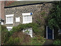
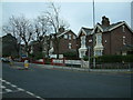
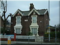
Oldest House in Bootle
This little house near the junction of Merton Road with Hawthorne Road is the oldest house in Bootle. The adjacent more modern house, now used as a solicitors, is dated 1773. The name Bootle comes from the Anglo Saxon "Bold" or "Botle" meaning a dwelling, it is mentioned in the Domesday Book and Merton Road was an ancient route from the shore to Walton-on-the-Hill. Bootle was originally a small rural hamlet built near the 'sand hills' or dunes of the river estuary with an abundant supply of fresh water from its springs. The settlement began to grow as a bathing resort for wealthy residents of Liverpool in the early 19th century.
Image: © Sue Adair
Taken: 20 Feb 2007
0.10 miles
5
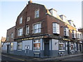
The Jawbone Tavern
The Jawbone Tavern on Litherland Road is the oldest in Bootle dating back to 1802, it is in the centre of what was the original Bootle Village which had grown from Saxon times around the important Bootle Spring. The original Jaw Bone is shown on the map of 1850 and was named after the famous Liverpool whaling fleets, at that time there was a whale blubber factory nearby, further down Litherland Road.
Image: © Sue Adair
Taken: 3 Jan 2020
0.14 miles
6
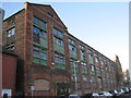
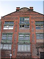
Bootle Tannery
The old Bootle Tanning Co building stands at the junction of Well Lane and Waterworks Street replacing the original Litherland Road Tannery. This had been built at this location to take advantage of the aquifer beneath Waterworks Street. The adjacent waterworks had drawn water from this source since the 1700's.
This later building, opened in 1900, is typical of a warehouse building of that era, cast iron pillars, wooden floors and brickwork with rounded corners. Now considered an eyesore, there have been plans over the years to convert the original building to apartments and construct houses on the site of the dilapidated office and warehouse buildings.
Image: © Sue Adair
Taken: 3 Jan 2020
0.15 miles
10
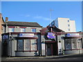
Stanley Arms, Litherland Road
The former Stanley Arms, 74 Litherland Road, now a day nursery. Note the Stanley family crest above the door.
Image: © Sue Adair
Taken: 3 Jan 2020
0.17 miles