IMAGES TAKEN NEAR TO
Miranda Place, LIVERPOOL, L20 2HW
Introduction
This page details the photographs taken nearby to Miranda Place, L20 2HW by members of the Geograph project.
The Geograph project started in 2005 with the aim of publishing, organising and preserving representative images for every square kilometre of Great Britain, Ireland and the Isle of Man.

There are currently over 7.5m images from over14,400 individuals and you can help contribute to the project by visiting https://www.geograph.org.uk
Image Map
Images are licensed for reuse under creativecommons.org/licenses/by-sa/2.0
Notes
- Clicking on the map will re-center to the selected point.
- The higher the marker number, the further away the image location is from the centre of the postcode.
Image Listing (62 Images Found)
Images are licensed for reuse under creativecommons.org/licenses/by-sa/2.0
Image
Details
Distance
1
St Lawrence with St Paul's Church, Kirkdale
Image: © Ian Greig
Taken: 2 Jan 2015
0.08 miles
2
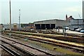
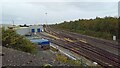
Kirkdale TMD
Viewed from Kirkdale railway station, a lone electric multiple unit is in one of the sidings. Behind the railway depot is the turret of the disused Royal public house, on Bankhall Street. Though not visible in the upload, looking at a closer photo, the train was later identified as Class 507 unit, 507009. Image
Image: © El Pollock
Taken: 13 Jun 2012
0.09 miles
5
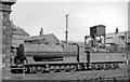
Ex-Lancashire & Yorkshire 0-8-0 at Bank Hall Locomotive Depot
See also Image No. 12782 is one of the survivors of a once numerous class of L&Y Aspinall Class 30 0-8-0s dating from 1901; it was withdrawn in 9/50, almost the last of its Class. Bank Hall Shed in Bootle was ahaven of ancient L&Y locomotives in 1948.
Image: © Ben Brooksbank
Taken: 20 Jun 1948
0.10 miles
7
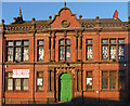
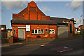
Former Bankhill Girls' Institute, Stanley Road, Liverpool
A lively example of Victorian paternalism or civic responsibility. "A project to assist working-class girls", complementing the slightly earlier Gordon Working Lads' Institute up the road. The style is loosely Jacobean. The upper pilasters (ish) are hanging with fruit and flowers, and above is a pierced parapet. The date in the gable is 1889.
It appeared to be occupied by Rydal Gym, offering "boxing for all". If we skate over the loaded phrase "working class", this is probably some distance from the Victorians' notion of assistance. It stands somewhat marooned amid scattered low-rise sheds, low-rise housing estates and patches of empty land.
Image: © Stephen Richards
Taken: 27 Jul 2011
0.10 miles
8
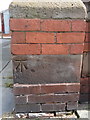
Bench mark on the Rydal Gym, Stanley Road
This Ordnance Survey bench mark is on the north west corner of the Rydal Gym, Stanley Road, Kirkdale. The gym was once the Bankhall Girls' Institute. Image
Image: © John S Turner
Taken: 31 Jul 2017
0.10 miles
9
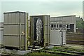
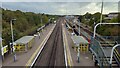
Washing Plant, Kirkdale TMD
Situated in the railway yard, next to the traction maintenance depot. In the background is the carriage shed. Viewed from a train, heading from Kirkdale to Sandhills.
Image: © El Pollock
Taken: 13 Jun 2012
0.10 miles