IMAGES TAKEN NEAR TO
Verney Crescent, LIVERPOOL, L19 4UR
Introduction
This page details the photographs taken nearby to Verney Crescent, L19 4UR by members of the Geograph project.
The Geograph project started in 2005 with the aim of publishing, organising and preserving representative images for every square kilometre of Great Britain, Ireland and the Isle of Man.

There are currently over 7.5m images from over14,400 individuals and you can help contribute to the project by visiting https://www.geograph.org.uk
Image Map
Images are licensed for reuse under creativecommons.org/licenses/by-sa/2.0
Notes
- Clicking on the map will re-center to the selected point.
- The higher the marker number, the further away the image location is from the centre of the postcode.
Image Listing (9 Images Found)
Images are licensed for reuse under creativecommons.org/licenses/by-sa/2.0
Image
Details
Distance
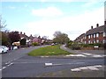
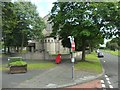
1
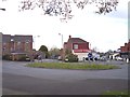
Roundabout where five roads meet at Allerton
Heath Road and Greenhill Road off to the right of the view
Image: © Raymond Knapman
Taken: 24 Apr 2012
0.11 miles
2
St Bernadettes Church on Mather Avenue Allerton
Image: © Raymond Knapman
Taken: 24 Apr 2012
0.16 miles
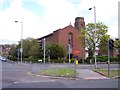
4
St Bernadette, Allerton
St Bernadette in Mather Avenue, Allerton.
Image: © Sue Adair
Taken: 6 Jun 2006
0.16 miles
6
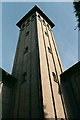
All Souls, Springwood
Tower detail.
Architects Campbell and Honeybourne, 1927
Image: © S Parish
Taken: Unknown
0.23 miles
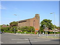
7
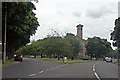
All Souls Church, Mather Avenue, Allerton
This CofE church is situated at the junction with Springwood Avenue, which goes uphill to the left.
Image: © El Pollock
Taken: 2 Aug 2012
0.24 miles
9
All Souls Church
Located on Mather Avenue at the junction with Springwood Avenue.
Image: © Stephen Sweeney
Taken: 21 Jun 2011
0.25 miles