IMAGES TAKEN NEAR TO
Clavell Road, LIVERPOOL, L19 4TS
Introduction
This page details the photographs taken nearby to Clavell Road, L19 4TS by members of the Geograph project.
The Geograph project started in 2005 with the aim of publishing, organising and preserving representative images for every square kilometre of Great Britain, Ireland and the Isle of Man.

There are currently over 7.5m images from over14,400 individuals and you can help contribute to the project by visiting https://www.geograph.org.uk
Image Map
Images are licensed for reuse under creativecommons.org/licenses/by-sa/2.0
Notes
- Clicking on the map will re-center to the selected point.
- The higher the marker number, the further away the image location is from the centre of the postcode.
Image Listing (19 Images Found)
Images are licensed for reuse under creativecommons.org/licenses/by-sa/2.0
Image
Details
Distance
1
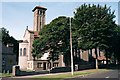
All Souls, Springwood
Architects, Campbell and Honeybourne. 1927
Image: © S Parish
Taken: Unknown
0.06 miles
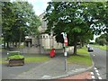
2
All Souls Church, Mather Avenue, Allerton
This CofE church is situated at the junction with Springwood Avenue, which goes uphill to the left.
Image: © El Pollock
Taken: 2 Aug 2012
0.09 miles
4
All Souls Church
Located on Mather Avenue at the junction with Springwood Avenue.
Image: © Stephen Sweeney
Taken: 21 Jun 2011
0.10 miles
5
Springwood Mansion from Springwood Avenue
Image: © Raymond Knapman
Taken: 24 Apr 2012
0.13 miles
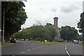
6
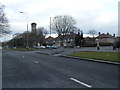
Mather Avenue at Danefield Road.
All Souls, Springwood, can be seen beyond.
Image: © Colin Pyle
Taken: 22 Feb 2010
0.13 miles
7
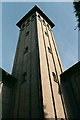
All Souls, Springwood
Tower detail.
Architects Campbell and Honeybourne, 1927
Image: © S Parish
Taken: Unknown
0.14 miles
8
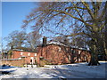
Stableblock, Springwood
Former stableblock of Thomas Brocklebank's Springwood mansion.
Image: © Sue Adair
Taken: 8 Jan 2010
0.15 miles
9
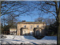
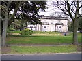
Springwood
The former neoclassical mansion house, Springwood, is dated 1839. It was originally built for plantation owner William Shand but was completed in 1844 under the auspices of Thomas Brocklebank of Brocklebank Shipping Line as his family residence. Bought by Liverpool Corporation in 1921 and passed through many hands in the following 50 years, it is now a residential nursing home named St Michael's Manor.
Image: © Sue Adair
Taken: 8 Jan 2010
0.15 miles
10
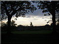
Springwood recreation ground at dusk
View south west with Garston Gasometer in the distance. Just visible are the Clwydian Hills in North Wales.
Image: © Colin Pyle
Taken: 26 Oct 2009
0.15 miles