IMAGES TAKEN NEAR TO
Booker Avenue, LIVERPOOL, L18 9TA
Introduction
This page details the photographs taken nearby to Booker Avenue, L18 9TA by members of the Geograph project.
The Geograph project started in 2005 with the aim of publishing, organising and preserving representative images for every square kilometre of Great Britain, Ireland and the Isle of Man.

There are currently over 7.5m images from over14,400 individuals and you can help contribute to the project by visiting https://www.geograph.org.uk
Image Map
Images are licensed for reuse under creativecommons.org/licenses/by-sa/2.0
Notes
- Clicking on the map will re-center to the selected point.
- The higher the marker number, the further away the image location is from the centre of the postcode.
Image Listing (11 Images Found)
Images are licensed for reuse under creativecommons.org/licenses/by-sa/2.0
Image
Details
Distance
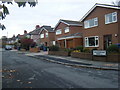
1

Booker Avenue
Looking towards Mather Avenue from Glendyke Road. The new block across the road is sheltered housing and a Synagogue, replacing a building from the 1950's
Image: © Colin Pyle
Taken: 26 Oct 2009
0.12 miles

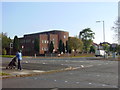
4
Allerton United Reformed Church
On Mather Avenue, Liverpool.
Image: © Ian S
Taken: 12 Jun 2019
0.16 miles

6
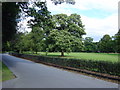
Entrance to Allerton Golf course
Allerton golf course has an 18 hole 5,500 yard par 67 and a 9 hole 1,841 yard par 34. This municipal course was constructed in the leafy suburbs of Liverpool and the club house is in the stable block of a large manor which was known as "Allerton" (proper name Obelisk House) a grand house which was twice destroyed by fire, in the early 1800's and in 1944. The shell stands forlornly near to the sandstone obelisk from which it took its name.There are other listed buildings in the grounds and it is a very pleasant environment to play, with many mature trees it is also a challenge!
Image: © Sue Adair
Taken: 28 Aug 2005
0.18 miles
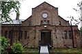
7
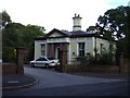
Gatehouse Allerton Golf Course
Grade II listed building, formerly the lodge of "Allerton" (proper name Obelisk House) a grand manor house which was twice destroyed by fire.
Image: © Sue Adair
Taken: 28 Aug 2005
0.18 miles
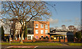
8
Synagogue, Mather Avenue, Allerton
Built in the early 1950's, this synagogue at the junction of Mather Avenue with Booker Avenue, Allerton was demolished in the summer of 2006 to avoid a spiralling repairs bill. Trustees struck a £3m deal with a housing company to replace the building with a smaller, modern one and also build a sheltered housing complex for elderly Jews on part of the site allowing ageing local residents to stay in the area near to their families and community.
Image: © Sue Adair
Taken: 27 Oct 2005
0.19 miles
9
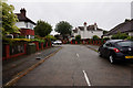
Gressingham Road off Mather Avenue, Liverpool
Image: © Ian S
Taken: 12 Jun 2019
0.20 miles