IMAGES TAKEN NEAR TO
North Mossley Hill Road, LIVERPOOL, L18 8BJ
Introduction
This page details the photographs taken nearby to North Mossley Hill Road, L18 8BJ by members of the Geograph project.
The Geograph project started in 2005 with the aim of publishing, organising and preserving representative images for every square kilometre of Great Britain, Ireland and the Isle of Man.

There are currently over 7.5m images from over14,400 individuals and you can help contribute to the project by visiting https://www.geograph.org.uk
Image Map
Images are licensed for reuse under creativecommons.org/licenses/by-sa/2.0
Notes
- Clicking on the map will re-center to the selected point.
- The higher the marker number, the further away the image location is from the centre of the postcode.
Image Listing (16 Images Found)
Images are licensed for reuse under creativecommons.org/licenses/by-sa/2.0
Image
Details
Distance
1
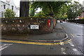
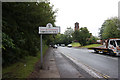
North Mossley Hill Road at Elmsley Road, Liverpool
Image: © Ian S
Taken: 12 Jun 2019
0.04 miles
2
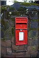
Postbox on North Mossley Hill Road, Liverpool
Image: © Ian S
Taken: 12 Jun 2019
0.04 miles
4
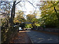
Liverpool College; bridge
Crossing a road, to connect two sections of the school.
Image: © Peter Barr
Taken: 3 Nov 2012
0.12 miles
7
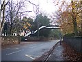
The Liverpool College's own bridge of sighs
A footbridge spans Greenbank Road
Image: © Raymond Knapman
Taken: 19 Nov 2010
0.14 miles
8
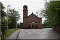
St Anthony of Padua Church
On Queens Drive, Liverpool.
Image: © Ian S
Taken: 12 Jun 2019
0.14 miles
9
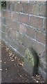
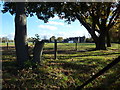
Old Boundary Marker
Parish Boundary Marker on the south side of Calderstone Road, set in the boundary wall of Calderstone Park, low down and west of the park's entrance. Liverpool metropolitan district. Inscribed T P (Toxteth Park). On the boundary of Toxteth Park and Wavertree townships. The W stone has disappeared. Reference http://www.liverpool.ndo.co.uk/wavsoc/news18/page23.html.
Milestone Society National ID: LA_LVTP01pb
Image: © M Chitty, Wavertree Society
Taken: 10 Aug 2018
0.17 miles
10
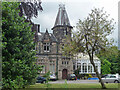
Holmestead, North Mossley Hill Road, Liverpool
The house was built c1845 by A.H. Holme, but most of what is seen here was the result of Culshaw & Sumners's enlargement of 1869-70. This includes the large cast-iron conservatory. Grade II listed.
Now flats I think.
Image: © Stephen Richards
Taken: 16 Jun 2016
0.21 miles