IMAGES TAKEN NEAR TO
Brodie Avenue, LIVERPOOL, L18 4PA
Introduction
This page details the photographs taken nearby to Brodie Avenue, L18 4PA by members of the Geograph project.
The Geograph project started in 2005 with the aim of publishing, organising and preserving representative images for every square kilometre of Great Britain, Ireland and the Isle of Man.

There are currently over 7.5m images from over14,400 individuals and you can help contribute to the project by visiting https://www.geograph.org.uk
Image Map
Images are licensed for reuse under creativecommons.org/licenses/by-sa/2.0
Notes
- Clicking on the map will re-center to the selected point.
- The higher the marker number, the further away the image location is from the centre of the postcode.
Image Listing (41 Images Found)
Images are licensed for reuse under creativecommons.org/licenses/by-sa/2.0
Image
Details
Distance
1
West Allerton, Ashbury Grange
Apartments off Dromore Avenue, West Allerton. Viewed across the railway line.
Image: © David Dixon
Taken: 30 Jan 2016
0.07 miles

3

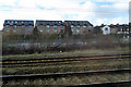
Disused platform, Mossley Hill railway station
The disused southern end of the island platform 1 & 2.
Image: © El Pollock
Taken: 17 Jan 2014
0.12 miles
4

East Midlands Trains Class 158, 158858, Mossley Hill railway station
The rear of the train is seen running through the station, with a service to Norwich.
Image: © El Pollock
Taken: 17 Jan 2014
0.13 miles
6

The view south, Mossley Hill railway station
The view along platform 2.
Image: © El Pollock
Taken: 17 Jan 2014
0.14 miles
7

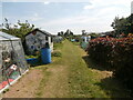
Holt Recreation Ground, Mossley Hill, Liverpool
Church of St Matthew & St James in the distance is just over the boundary in the next 1km square.
Image: © John Lord
Taken: 26 Dec 2011
0.14 miles
9

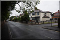
Old Boundary Marker
Parish Boundary Marker on the southeast side of Rose Lane, against the stone wall of Clearview. Liverpool metropolitan district. Inscribed W │G (for Wavertree and Garston). Showing the boundary of Wavertree and Garston townships' responsibility for road maintenance. Reference http://www.liverpool.ndo.co.uk/wavsoc/news20/index.html. Grade II Listed https://historicengland.org.uk/listing/the-list/list-entry/1209761.
Milestone Society National ID: LA_LVWVGA01pb
Image: © M Chitty, Wavertree Society
Taken: 10 Aug 2018
0.15 miles
10

London Midland Class 350, 350257, Mossley Hill railway station
The train runs through the station with a service to Liverpool.
Image: © El Pollock
Taken: 17 Jan 2014
0.15 miles