IMAGES TAKEN NEAR TO
Calderfield Road, LIVERPOOL, L18 3HB
Introduction
This page details the photographs taken nearby to Calderfield Road, L18 3HB by members of the Geograph project.
The Geograph project started in 2005 with the aim of publishing, organising and preserving representative images for every square kilometre of Great Britain, Ireland and the Isle of Man.

There are currently over 7.5m images from over14,400 individuals and you can help contribute to the project by visiting https://www.geograph.org.uk
Image Map (Loading...)


Getting Data...Please wait
Leaflet Map data © OpenStreetMap
Images are licensed for reuse under creativecommons.org/licenses/by-sa/2.0
Notes
- Clicking on the map will re-center to the selected point.
- The higher the marker number, the further away the image location is from the centre of the postcode.
Image Listing (8 Images Found)
Images are licensed for reuse under creativecommons.org/licenses/by-sa/2.0
Image
Details
Distance
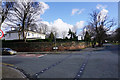
3
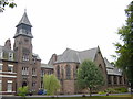
Bishop Eton Monastery, Woolton
Bishop Eton Monastery on Woolton Road near to the junction with Crompton's Lane.
Image: © Sue Adair
Taken: 16 Aug 2005
0.13 miles
4
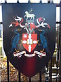
The crest of Liverpool Hope University
On the gates of the Woolton Road site. The Greek inscription means " In faith, in hope and love".
Image: © Peter Barr
Taken: 3 Nov 2012
0.15 miles
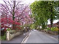
6
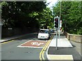
Cromptons Lane
Leading towards Childwall.
Image: © Bill Boaden
Taken: 21 Feb 2015
0.19 miles
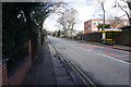
7
Carleton House
A prep school overlooking the junction of Menlove Avenue and Cromptons Lane.
Image: © Bill Boaden
Taken: 21 Feb 2015
0.19 miles
8
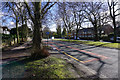
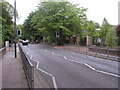
Menlove Avenue
The shadows of the winter trees are making a pattern of lines on the road.
Image: © Bill Boaden
Taken: 21 Feb 2015
0.22 miles