IMAGES TAKEN NEAR TO
Cromptons Lane, LIVERPOOL, L18 3EU
Introduction
This page details the photographs taken nearby to Cromptons Lane, L18 3EU by members of the Geograph project.
The Geograph project started in 2005 with the aim of publishing, organising and preserving representative images for every square kilometre of Great Britain, Ireland and the Isle of Man.

There are currently over 7.5m images from over14,400 individuals and you can help contribute to the project by visiting https://www.geograph.org.uk
Image Map
Images are licensed for reuse under creativecommons.org/licenses/by-sa/2.0
Notes
- Clicking on the map will re-center to the selected point.
- The higher the marker number, the further away the image location is from the centre of the postcode.
Image Listing (17 Images Found)
Images are licensed for reuse under creativecommons.org/licenses/by-sa/2.0
Image
Details
Distance
1
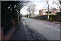
Cromptons Lane
Leading towards Childwall.
Image: © Bill Boaden
Taken: 21 Feb 2015
0.08 miles
2
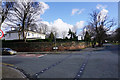
Carleton House
A prep school overlooking the junction of Menlove Avenue and Cromptons Lane.
Image: © Bill Boaden
Taken: 21 Feb 2015
0.09 miles
3
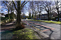
Menlove Avenue
The shadows of the winter trees are making a pattern of lines on the road.
Image: © Bill Boaden
Taken: 21 Feb 2015
0.10 miles
5
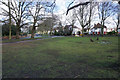
Green space by Green Lane
The white bits are snowdrops heralding spring on the way.
Image: © Bill Boaden
Taken: 21 Feb 2015
0.18 miles
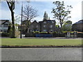
6

Bishop Eton Monastery, Woolton
Bishop Eton Monastery on Woolton Road near to the junction with Crompton's Lane.
Image: © Sue Adair
Taken: 16 Aug 2005
0.18 miles
7

Green Lane near Childwall
Part of an area of leafy suburbs.
Image: © Bill Boaden
Taken: 21 Feb 2015
0.20 miles

9

Old Boundary Marker
Parish Boundary Marker on the south side of Calderstone Road, set in the boundary wall of Calderstone Park, low down and west of the park's entrance. Liverpool metropolitan district. Inscribed L W │ W (for Little Woolton and Wavertree). On the boundary of Little Woolton and Wavertree townships. Reference http://www.liverpool.ndo.co.uk/wavsoc/news19/page14.html.
Milestone Society National ID: LA_LVLWWV01pb
Image: © M Chitty, Wavertree Society
Taken: 14 Sep 2018
0.21 miles