IMAGES TAKEN NEAR TO
Druids Cross Gardens, LIVERPOOL, L18 3ED
Introduction
This page details the photographs taken nearby to Druids Cross Gardens, L18 3ED by members of the Geograph project.
The Geograph project started in 2005 with the aim of publishing, organising and preserving representative images for every square kilometre of Great Britain, Ireland and the Isle of Man.

There are currently over 7.5m images from over14,400 individuals and you can help contribute to the project by visiting https://www.geograph.org.uk
Image Map
Images are licensed for reuse under creativecommons.org/licenses/by-sa/2.0
Notes
- Clicking on the map will re-center to the selected point.
- The higher the marker number, the further away the image location is from the centre of the postcode.
Image Listing (24 Images Found)
Images are licensed for reuse under creativecommons.org/licenses/by-sa/2.0
Image
Details
Distance
2
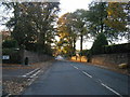
Menlove Avenue
Heading towards Mendips where John Lennon spent his early years.
Image: © alan fairweather
Taken: 12 May 2004
0.13 miles
3
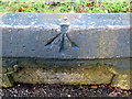
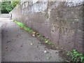
Rivet bench mark on the Calderstones surround
This early Ordnance Survey bench mark is cut into the west face of the stone surround where the Calderstones once stood. The historic stones have been moved to a more secure location, but the stone surround still stands in the middle of Calderstones Road opposite the park entrance. The bench mark was first recorded on the 1849 map and although it is currently listed as a rivet, which is set further back, originally it appears to have been a pivot. See also Image
Image: © John S Turner
Taken: 18 Jan 2011
0.14 miles
4
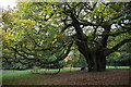
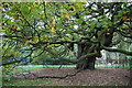
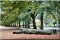
The Allerton Oak, Calderstones Park
Ancient oak, said to be 1000 years old.
Image: © Mike Pennington
Taken: 20 Oct 2015
0.15 miles
5
The Calderstones surround and park entrance
Looking across the stone surround that once protected the Calderstones, opposite the north east entrance to Calderstones Park. The Calderstones themselves are highly ornamented and are believed to have been part of a chambered tomb, and not actually a stone circle when they were found. The protective stone surround was built in the 19th century, but the stones were moved in 1954 to the park's Harthill Greenhouses in order to protect them from further damage or deterioration. Sue Adair's photo provides more information: Image
There is an Ordnance Survey rivet bench mark on the opposite side of the surround, nearest to the park entrance - Image
Image: © John S Turner
Taken: 18 Jan 2011
0.15 miles
6
The Allerton Oak, Calderstones Park
Ancient oak, believed to be 1000 years old.
Image: © Mike Pennington
Taken: 20 Oct 2015
0.15 miles
7
Old Boundary Marker
Parish Boundary Marker on the south side of Calderstone Road, set in the boundary wall of Calderstone Park, low down and west of the park's entrance. Liverpool metropolitan district. Inscribed L W │ W (for Little Woolton and Wavertree). On the boundary of Little Woolton and Wavertree townships. Reference http://www.liverpool.ndo.co.uk/wavsoc/news19/page14.html.
Milestone Society National ID: LA_LVLWWV01pb
Image: © M Chitty, Wavertree Society
Taken: 14 Sep 2018
0.16 miles
8
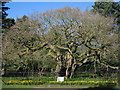
The Allerton Oak
The ancient Allerton Oak stands in Calderstones Park. Thought to be a 1,000 years old, the local Hundred court is said to have met beneath its branches.
Image: © Sue Adair
Taken: 29 Mar 2009
0.16 miles
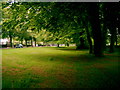
10
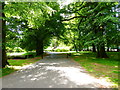
Calderstones Park
A 94 acre park in South Liverpool. This is the path into the park from Calderstones Road.
Image: © Eirian Evans
Taken: 31 May 2016
0.17 miles