IMAGES TAKEN NEAR TO
St. Michaels Road, LIVERPOOL, L17 7AW
Introduction
This page details the photographs taken nearby to St. Michaels Road, L17 7AW by members of the Geograph project.
The Geograph project started in 2005 with the aim of publishing, organising and preserving representative images for every square kilometre of Great Britain, Ireland and the Isle of Man.

There are currently over 7.5m images from over14,400 individuals and you can help contribute to the project by visiting https://www.geograph.org.uk
Image Map
Images are licensed for reuse under creativecommons.org/licenses/by-sa/2.0
Notes
- Clicking on the map will re-center to the selected point.
- The higher the marker number, the further away the image location is from the centre of the postcode.
Image Listing (24 Images Found)
Images are licensed for reuse under creativecommons.org/licenses/by-sa/2.0
Image
Details
Distance
1
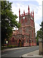
St Michaels in the hamlet church
St. Michael's was consecrated on 21st June 1815, its first service being a thanksgiving for victory at the Battle of Waterloo. It was the second of Liverpool's 'cast iron churches'. Its builder, John Cragg, was principal partner in the Mersey Iron Foundry in Tithebarn Street and its architect, Thomas Rickman, was committed to a revival of Gothic design. Cast iron was used where ever possible in the construction of the church, from its frame to intricate Gothic mouldings and ornamental work, both internal and external.
Image: © Sue Adair
Taken: 16 Aug 2005
0.08 miles
2
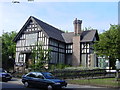
Lark Lane Library
This attractive building housing a library is situated in Aigburth road near the junction with Lark Lane.
Image: © Sue Adair
Taken: 15 Aug 2005
0.11 miles
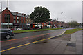
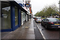
4

Aigburth Road
The A561 near Sefton Park. There are frequent buses into the city centre. On the other side is Sefton Park Library, a Carnegie library which has been suggested for possible closure.
Image: © Bill Boaden
Taken: 23 Mar 2019
0.11 miles

10
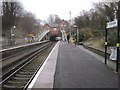
St. Michaels railway station, Merseyside
Opened in 1864 on what became the Cheshire Line Committee's main line from Manchester Central to Liverpool Central via Warrington. The station closed in 1972 but was reopened in 1978 as part of Merseyrail's Northern line from Hunts Cross to Liverpool. View south east towards Aigburth and Hunts Cross.
Image: © Nigel Thompson
Taken: 22 Jan 2011
0.17 miles