IMAGES TAKEN NEAR TO
Hilltop Road, LIVERPOOL, L16 7QP
Introduction
This page details the photographs taken nearby to Hilltop Road, L16 7QP by members of the Geograph project.
The Geograph project started in 2005 with the aim of publishing, organising and preserving representative images for every square kilometre of Great Britain, Ireland and the Isle of Man.

There are currently over 7.5m images from over14,400 individuals and you can help contribute to the project by visiting https://www.geograph.org.uk
Image Map
Images are licensed for reuse under creativecommons.org/licenses/by-sa/2.0
Notes
- Clicking on the map will re-center to the selected point.
- The higher the marker number, the further away the image location is from the centre of the postcode.
Image Listing (16 Images Found)
Images are licensed for reuse under creativecommons.org/licenses/by-sa/2.0
Image
Details
Distance
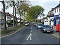
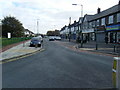
2
Corbridge Road at Hilltop Road junction.
Image: © Colin Pyle
Taken: 20 Jan 2010
0.08 miles
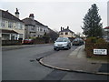
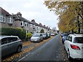
3
Childwall Priory Road
Part of a large residential area.
Image: © Bill Boaden
Taken: 21 Feb 2015
0.10 miles
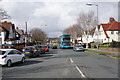
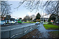
5
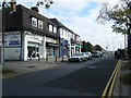
Dunbabin Road
Looking east to junction with Taggart Avenue. Shops and Post Office on the left.
Image: © Colin Pyle
Taken: 17 Oct 2009
0.12 miles
6
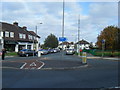
Dunbabin Road/Taggart Avenue
Junction at west side of the Triangle.
Image: © Colin Pyle
Taken: 17 Oct 2009
0.12 miles
7
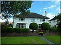
Brian Epstein's family home
The home in which the Beatles manager spent much of his life.
Image: © Stephen Sweeney
Taken: 21 Jun 2011
0.12 miles
8
Green Lane North an autumnal scene
Looking north toward Dunbabin Road
Image: © Martin Dawes
Taken: 10 Nov 2018
0.15 miles
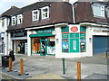
10
Shops at Childwall Triangle
Childwall Priory Road / Dunbabin Road shops.
Image: © Colin Pyle
Taken: 17 Oct 2009
0.18 miles