IMAGES TAKEN NEAR TO
Lakeland Close, LIVERPOOL, L1 5HY
Introduction
This page details the photographs taken nearby to Lakeland Close, L1 5HY by members of the Geograph project.
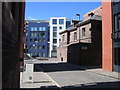
The Geograph project started in 2005 with the aim of publishing, organising and preserving representative images for every square kilometre of Great Britain, Ireland and the Isle of Man.

There are currently over 7.5m images from over14,400 individuals and you can help contribute to the project by visiting https://www.geograph.org.uk
Image Map
Images are licensed for reuse under creativecommons.org/licenses/by-sa/2.0
Notes
- Clicking on the map will re-center to the selected point.
- The higher the marker number, the further away the image location is from the centre of the postcode.
Image Listing (362 Images Found)
Images are licensed for reuse under creativecommons.org/licenses/by-sa/2.0
Image
Details
Distance
1
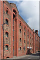
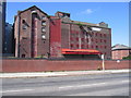
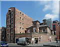
12 York Street, Liverpool
One of several "particularly impressive" warehouses in the area, wrote Pevsner, by David Walker, 1884. Between piers are bays corbelled out at the top, "giving an almost fortified look". Grade II listed.
The far section is clearer here: Image
This is now flats.
Image: © Stephen Richards
Taken: 27 Jul 2011
0.04 miles
2
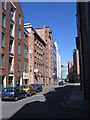
View along Argyle Street towards Hanover Street
There is a mixture of old and modern apartment buildings and offices in this street.
Image: © John S Turner
Taken: 10 Jun 2008
0.05 miles
3
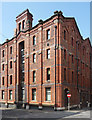
18 Henry Street, Liverpool
One of several "particularly impressive" warehouses in the area, wrote Pevsner, by David Walker, 1884. A virtuoso essay in polychromatic brickwork. Between buttresses are bays corbelled out at the top, "giving an almost fortified look". Grade II listed.
This is now flats.
Image: © Stephen Richards
Taken: 27 Jul 2011
0.06 miles
4
Campbell Square from Henry Street
This modern square between Henry Street and Argyle Street has been created by closing off the end of Campbell Street. On the corner of the old wall is the entrance to the former prison, but now a smart restaurant, Jalon's Bridewell http://www.jalonsbridewell.co.uk/
Image: © John S Turner
Taken: 10 Jun 2008
0.06 miles
5
Warehouse next to Park Lane
Looking across Park Lane towards the old warehouse that, on the end wall, carries the name of Joseph Heap & Sons Ltd, Rice Millers. I think the faded white sign to the top right says 'RICE MILL'.
Image: © John S Turner
Taken: 10 Jun 2008
0.07 miles
6
Campbell Square
This modern square is at the end of Campbell Street between Henry Street and Argyle Street.
Image: © John S Turner
Taken: 10 Jun 2008
0.07 miles
7
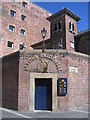
The entrance to Jalon's Bridewell
This former prison, on the corner of Argyle Street and Campbell Square, is now a smart restaurant http://www.jalonsbridewell.co.uk/
Image: © John S Turner
Taken: 10 Jun 2008
0.07 miles
8
Jalon's Bridewell
Looking across Campbell Street from Henry Street towards Jalon's Bridewell. This former prison is now a smart restaurant http://www.jalonsbridewell.co.uk/
Image: © John S Turner
Taken: 10 Jun 2008
0.08 miles
9
Campbell Street between Duke Street and Argyle Street
Campbell Street is divided by Duke Street and whilst the northern part is narrow and dark this section is much wider. The old building on the right is a former prison that is now a smart restaurant, Jalon's Bridewell http://www.jalonsbridewell.co.uk/
Image: © John S Turner
Taken: 10 Jun 2008
0.08 miles
10
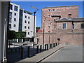
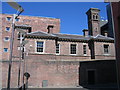
Warehouse and the former Bridewell, Argyle Street, Liverpool
The warehouse, now flats, dates probably from the early C19th. The old hoist canopy survives at the top. Grade II listed.
The Bridewell, which contained cells and police offices, dates from 1861. The taller tower behind was for ventilation. Now a restaurant. Grade II listed.
Image: © Stephen Richards
Taken: 27 Jul 2011
0.08 miles