IMAGES TAKEN NEAR TO
Church Road, LIVERPOOL, L15 9EA
Introduction
This page details the photographs taken nearby to Church Road, L15 9EA by members of the Geograph project.
The Geograph project started in 2005 with the aim of publishing, organising and preserving representative images for every square kilometre of Great Britain, Ireland and the Isle of Man.

There are currently over 7.5m images from over14,400 individuals and you can help contribute to the project by visiting https://www.geograph.org.uk
Image Map
Images are licensed for reuse under creativecommons.org/licenses/by-sa/2.0
Notes
- Clicking on the map will re-center to the selected point.
- The higher the marker number, the further away the image location is from the centre of the postcode.
Image Listing (49 Images Found)
Images are licensed for reuse under creativecommons.org/licenses/by-sa/2.0
Image
Details
Distance
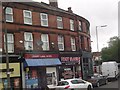
3
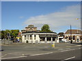
Heathfield Road junction with Church Road
Looking down Heathfield Road. Church Road forms the triangular junction on the left, with 'The Shelter in the Middle of the Roundabout' within. The barbers on the right is also in the Beatles Song, but was Bioletti's back then. Penny Lane can be seen ahead, across the main road and going beyond the white building in the distance. The song isn't about Penny Lane itself, which was quite minor, but refers to that end of Allerton Road where the bus destination said Penny Lane. No buses went down the lane itself.
Image: © Colin Pyle
Taken: 11 Oct 2009
0.03 miles
4
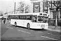
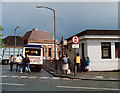
Bus at Penny Lane bus terminus - 1968
Route 99 was one of the first in Liverpool to be converted to one-person-operation, using Leyland Panthers with MCW bodywork. 1023 is one of these and was brand new at the time.
It is standing on Church Road outside the impressive Welsh Methodist Church. This was demolished around 2010, leaving just the entrance steps as a reminder. See https://goo.gl/maps/J1GuBwzyKwiJbPNA8 and https://goo.gl/maps/Jj5rmVC4NgXHgsGo8
This is one of a series of views featuring buses in the 60s, 70s, and 80s. http://www.geograph.org.uk/search.php?i=137652761
Image: © Alan Murray-Rust
Taken: 12 Dec 1968
0.05 miles
5
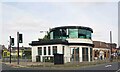
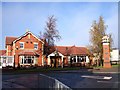
Wavertree: 'The shelter in the middle of a roundabout'
Behind which a pretty nurse is selling poppies from a tray....
Anyway this structure was once the bus shelter and public conveniences in Smithdown Place at the north-eastern end of Penny Lane. It has since been converted into Sgt Pepper's Bistro, but was closed at the time of the photograph.
Comparing this image with Sue Adair's from August 2005 Image it is evident that the circular glass fronted first floor room has been added since.
A review of Street View images shows that it was not present in October 2012 but largely complete by July 2015.
Image: © Nigel Cox
Taken: 24 Jul 2021
0.06 miles
6
A shelter in the middle of a roundabout, 1988
As featured in the song "Penny Lane", this was one of the stops on a Beatles Heritage Coach Tour. The bank in the background is believed to be that of "the banker" mentioned in the song.
Image: © Keith Edkins
Taken: 3 Jun 1988
0.06 miles
7
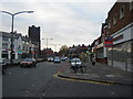
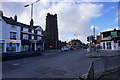
Allerton Road
Looking towards city from corner of Plattsville Road. Beyond the church is Penny Lane on the left. On the right is the closed Woolworth store.
Image: © Colin Pyle
Taken: 26 Oct 2009
0.07 miles
8
Penny Lane
The famous "shelter in the middle of the roundabout" as sung by the Beatles in their song Penny Lane. Situated at the busy junction with Allerton Road, it is presently a cafe called Sgt Pepper's.
Image: © Sue Adair
Taken: 28 Aug 2005
0.07 miles
9
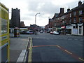
Multiple road junction in Heathfield
Six roads meet here, one of which is the famous Penny Lane just to the right of St Barnabas' Church.
Image: © Bill Boaden
Taken: 21 Feb 2015
0.07 miles
10
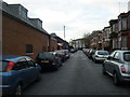
Auckland Road
The rear of the closed Woolworth store on the left.
Image: © Colin Pyle
Taken: 26 Oct 2009
0.08 miles