IMAGES TAKEN NEAR TO
Titherington Way, LIVERPOOL, L15 3JN
Introduction
This page details the photographs taken nearby to Titherington Way, L15 3JN by members of the Geograph project.
The Geograph project started in 2005 with the aim of publishing, organising and preserving representative images for every square kilometre of Great Britain, Ireland and the Isle of Man.

There are currently over 7.5m images from over14,400 individuals and you can help contribute to the project by visiting https://www.geograph.org.uk
Image Map
Images are licensed for reuse under creativecommons.org/licenses/by-sa/2.0
Notes
- Clicking on the map will re-center to the selected point.
- The higher the marker number, the further away the image location is from the centre of the postcode.
Image Listing (38 Images Found)
Images are licensed for reuse under creativecommons.org/licenses/by-sa/2.0
Image
Details
Distance
2
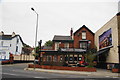
Willow Bank Tavern, Wavertree
A pub which always has a good range of beers.
Image: © Bill Boaden
Taken: 19 Oct 2013
0.02 miles
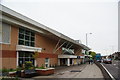
5
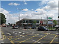
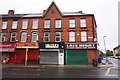
ASDA Smithdown Road
The junction of Smithdown Road with Bagot Street and the new ASDA built on the site of Sefton General Hospital.
Image: © Sue Adair
Taken: 26 Jun 2007
0.08 miles
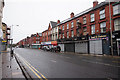
6
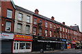
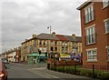
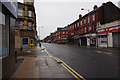
Row of shops on Smithdown Road, Wavertree
The range of shops is now limited, as with most suburbs.
Image: © Bill Boaden
Taken: 19 Oct 2013
0.09 miles