IMAGES TAKEN NEAR TO
Bligh Street, LIVERPOOL, L15 0HF
Introduction
This page details the photographs taken nearby to Bligh Street, L15 0HF by members of the Geograph project.
The Geograph project started in 2005 with the aim of publishing, organising and preserving representative images for every square kilometre of Great Britain, Ireland and the Isle of Man.

There are currently over 7.5m images from over14,400 individuals and you can help contribute to the project by visiting https://www.geograph.org.uk
Image Map
Images are licensed for reuse under creativecommons.org/licenses/by-sa/2.0
Notes
- Clicking on the map will re-center to the selected point.
- The higher the marker number, the further away the image location is from the centre of the postcode.
Image Listing (24 Images Found)
Images are licensed for reuse under creativecommons.org/licenses/by-sa/2.0
Image
Details
Distance
1
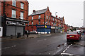
Best 4 Students
At Peel House, Lawrence Road, Liverpool.
Image: © Ian S
Taken: 12 Jun 2019
0.04 miles
3
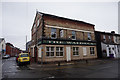
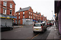
The Waldeck
A former public house now student accommodation on Lawrence Road, Liverpool
Image: © Ian S
Taken: 12 Jun 2019
0.06 miles
4
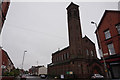
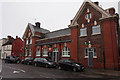
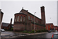
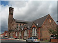
St Bridget & St Thomas Church
On Lawrence Road, Liverpool.
Image: © Ian S
Taken: 12 Jun 2019
0.07 miles
8
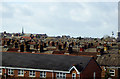
Liverpool Rooftops
Looking over the rooftops at Wavertree from a train approaching Liverpool. The Radio City Tower and Metropolitan Cathedral are easily recognisable landmarks which have 'sneaked' into the photo on the right hand side.
Image: © David Dixon
Taken: 30 Jan 2016
0.09 miles