1
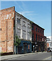
36-40 Seel Street, Liverpool
A pair of derelict early C20th former warehouses (?) which have since been demolished for flats.
At one time, the far building housed the Liverpool Actors Studio Theatre.
Image: © Stephen Richards
Taken: 12 Jun 2015
0.01 miles
2
15-17 Seel Street, Liverpool
Only the (offbeat) Victorian facade remains. Inscribed above the windows is "Brockbank and Mellor", late-C19th wine merchants.
Image: © Stephen Richards
Taken: 27 Jul 2011
0.02 miles
3
Building in Wolstenholme Square, Liverpool L1
This old building in Wolstenholme Square has a date and initials over the pink door - 'GW 1909'. Might they refer to a George Wolstenholme? See also
Image
Image: © John S Turner
Taken: 6 Jan 2011
0.02 miles
4
Doorway in Wolstenholme Square, Liverpool L1
This doorway is on the north east side of Wolstenholme Square. Over the door are the initials and date - 'GW 1909'. Perhaps they refer to a George Wolstenholme? See also
Image
Image: © John S Turner
Taken: 6 Jan 2011
0.03 miles
5
Humyak House
This Duke Street warehouse, which has been given a Grade II listing, has survived relatively unspoiled since it was built in 1864 and represents a typical mercantile warehouse of the mid-Victorian period.
Image: © Eirian Evans
Taken: 24 Jan 2009
0.03 miles
6
'Cream' buildings in Wolstenholme Square
One of the most famous names in clubbing has its home in Wolstenholme Square.
Image: © John S Turner
Taken: 6 Jan 2011
0.04 miles
7
'Penelope' in Wolstenholme Square, Liverpool L1
This art installation/sculpture in Wolstenholme Square is called Penelope. It was created by the Cuban-born sculptor Jorge Pardo who created it for the 2006 Biennial. It is inspired by Homer's Odyssey in which Penelope, the wife of Odysseus (Ulysses in Roman mythology), knitted constantly in order to remain faithful to her husband. http://www.liverpoolmonuments.co.uk/sculpture/penelope.html
Image: © John S Turner
Taken: 6 Jan 2011
0.04 miles
8
Gradwell Street, Liverpool L1
Looking along Gradwell Street in the direction of Hanover Street. The premises of Hastie & Patterson are on the left -
Image
Image: © John S Turner
Taken: 6 Jan 2011
0.05 miles
9
Mural, Fleet Street
A mural on the wall of the Mood nightclub on Fleet Street.
Image: © Eirian Evans
Taken: 20 Feb 2012
0.05 miles
10
Parr Street, Liverpool L1
Looking along Parr Street towards Wolstenholme Square with the famous 'nation' nightclub on the right. Although not clear in this photo the black-painted wall on the right is curved suggesting a once grand Georgian building. By 1955 it is recorded as a ruin on the O.S. map, but earlier maps show that there was once one of Liverpool's notorious 'courts' (very poor quality housing) in an alley to the right - also named Blakley Place up to 1864.
This website has a description of court living: http://www.discover-liverpool.com/24/section.aspx/3
Image: © John S Turner
Taken: 6 Jan 2011
0.05 miles


