IMAGES TAKEN NEAR TO
Slater Street, LIVERPOOL, L1 4BW
Introduction
This page details the photographs taken nearby to Slater Street, L1 4BW by members of the Geograph project.
The Geograph project started in 2005 with the aim of publishing, organising and preserving representative images for every square kilometre of Great Britain, Ireland and the Isle of Man.

There are currently over 7.5m images from over14,400 individuals and you can help contribute to the project by visiting https://www.geograph.org.uk
Image Map (Loading...)


Getting Data...Please wait
Leaflet Map data © OpenStreetMap
Images are licensed for reuse under creativecommons.org/licenses/by-sa/2.0
Notes
- Clicking on the map will re-center to the selected point.
- The higher the marker number, the further away the image location is from the centre of the postcode.
Image Listing (449 Images Found)
Images are licensed for reuse under creativecommons.org/licenses/by-sa/2.0
Image
Details
Distance
1
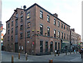
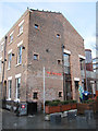
13-25 Slater Street, Liverpool
No. 13, on the corner of Fleet Street, is an early C19th former warehouse and house; there follows a short, probably contemporary, terrace.
Now the Shipping Forecast, a bar and music venue. On the far corner is O'Brien's pub (Image]).
Image: © Stephen Richards
Taken: 11 Jun 2015
0.02 miles
2
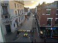
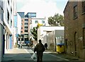
Slater Street
Taken early on Sunday morning, when most of the revellers had gone home.
Image: © Bikeboy
Taken: 29 Jan 2022
0.02 miles
3
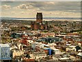
View to the South East from St John's Beacon
The Radio City viewing gallery at St John’s Beacon provides excellent panoramic and bird's eye views of the city and beyond (http://www.radiocity.co.uk/local/radio-city-viewing-gallery/ Radio City). The most prominent building in this view is Liverpool's Anglican Cathedral (SJ 354 894)
Image: © David Dixon
Taken: 27 Apr 2015
0.03 miles
5
Fleet Street with Superlambanana
"The Rope Walker" Superlambanana atop BDP, Fleet Street, as part of the Go Superlambananas! exhibition which placed 125 Superlambananas in and around Liverpool for the European Capital of Culture 2008 celebrations.
Image: © Lauren
Taken: 12 Jul 2008
0.04 miles
6
The Peacock, 49-51 Seel Street
The Peacock is a cocktail bar at 49-51 Seel Street. http://www.peacock-liverpool.com/ Along with its neighbours 45 and 47 the building is Grade II listed http://list.english-heritage.org.uk/resultsingle.aspx?uid=1292329 Outside the building the Peacock Superlambanana can be seen.
Image: © John S Turner
Taken: 6 Jan 2011
0.04 miles
7
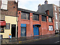
The Zanzibar Club, 43 Seel Street
The Zanzibar Club is a nightclub at 43 Seel Street, next door to the Marlborough pub. http://www.thezanzibarclub.com/ The building used to be a clothing factory.
Image: © John S Turner
Taken: 6 Jan 2011
0.04 miles
8
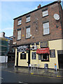
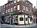
The Marlborough, Seel Street
The Marlborough public house is on the corner of Seel Street and Slater Street. In 1850 a building on this site is recorded on the town plans as 'S.V.' This is probably an abbreviation for 'Spirit Vaults', a term more common at that time.
Image: © John S Turner
Taken: 6 Jan 2011
0.04 miles
9
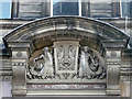
Detail of 43-47 Bold Street, Liverpool
Segmental pediment above the entrance to a former branch of the Union Bank of Liverpool (1885, by G.E. Grayson). A merman and mermaid flank a pair of dragons (?) and the inscription "vis unita fortior", which I understand translates as "united strength is stronger".
Local pigeons clearly have scant regard for the carvers' handiwork.
Image: © Stephen Richards
Taken: 27 Jul 2011
0.04 miles
10
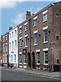
45-51 Seel Street, Liverpool
Late-C18th houses. No. 47 is larger and painted. Grade II listed.
Recently spruced up - the pointing has clearly been renewed - and in use as a bar, The Peacock (nos. 49-51), solicitors' offices (no. 47), and flats (no. 45).
Image: © Stephen Richards
Taken: 27 Jul 2011
0.05 miles