IMAGES TAKEN NEAR TO
Pilch Lane, LIVERPOOL, L14 0JF
Introduction
This page details the photographs taken nearby to Pilch Lane, L14 0JF by members of the Geograph project.
The Geograph project started in 2005 with the aim of publishing, organising and preserving representative images for every square kilometre of Great Britain, Ireland and the Isle of Man.

There are currently over 7.5m images from over14,400 individuals and you can help contribute to the project by visiting https://www.geograph.org.uk
Image Map
Images are licensed for reuse under creativecommons.org/licenses/by-sa/2.0
Notes
- Clicking on the map will re-center to the selected point.
- The higher the marker number, the further away the image location is from the centre of the postcode.
Image Listing (10 Images Found)
Images are licensed for reuse under creativecommons.org/licenses/by-sa/2.0
Image
Details
Distance
1
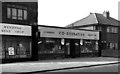
Co-operative Food Store, Pilch Lane, Liverpool. 1955
Liverpool Co-operative Society's number 128 branch in Pilch Lane, Liverpool, a typical suburban co-op grocery store.
Note the how up to date it is --- "self service"!
Trying out my "new" 35mm camera, this was photographed, on a Sunday morning in 1955, when I was visiting the branch to conduct a stockcheck.
A most welcome bit of overtime!
Image: © Gordon Cragg
Taken: 13 Mar 1955
0.04 miles
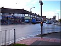
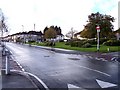
3

Pilch Lane
Pilch Lane Pharmacy and Doctor's Surgery and in the trees Ashfarm Court retirement housing which was built on the site of an old dairy farm. The milkman used to deliver milk by horse and cart to all the local area.
Image: © Sue Adair
Taken: 18 Feb 2021
0.10 miles
5
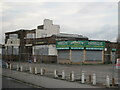
The Boundary Pub
The Boundary Pub taken in November 2010 not long before demolition.
Image: © Sue Adair
Taken: 22 Nov 2010
0.19 miles
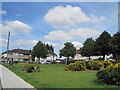
6
Garden oasis on Milton Avenue
A small crescent shaped garden brightens the urban landscape
Image: © Raymond Knapman
Taken: 19 Oct 2010
0.19 miles
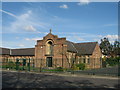
8
St Margaret Mary's RC Church
St Margaret Mary's RC Church on Pilch Lane was built in 1932 and the present church was opened in 1964.
Image: © Sue Adair
Taken: 20 Apr 2018
0.20 miles
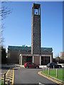
9
St Margaret Mary RC Church
The church of St Margaret Mary, its openwork concrete campanile is a local landmark and the hourly bell a familiar sound. The octagonal lantern with folded copper roof is an unusual feature of the church which was built in 1962 to replace the very plain original building of 1932.
This view looks across the site of the Boundary Public House which has been empty since the pub closed in 2008 and demolished in 2011.
Image: © Sue Adair
Taken: 18 Feb 2021
0.23 miles
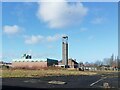
10
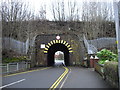
Railway bridge, Childwall Lane, Liverpool
Image: © John Lord
Taken: 28 Dec 2012
0.25 miles