IMAGES TAKEN NEAR TO
West Derby Road, LIVERPOOL, L13 7HQ
Introduction
This page details the photographs taken nearby to West Derby Road, L13 7HQ by members of the Geograph project.
The Geograph project started in 2005 with the aim of publishing, organising and preserving representative images for every square kilometre of Great Britain, Ireland and the Isle of Man.

There are currently over 7.5m images from over14,400 individuals and you can help contribute to the project by visiting https://www.geograph.org.uk
Image Map
Images are licensed for reuse under creativecommons.org/licenses/by-sa/2.0
Notes
- Clicking on the map will re-center to the selected point.
- The higher the marker number, the further away the image location is from the centre of the postcode.
Image Listing (14 Images Found)
Images are licensed for reuse under creativecommons.org/licenses/by-sa/2.0
Image
Details
Distance
1
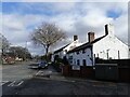
18th Century cottage, Tuebrook
This 18th Century cottage on the corner of West Derby Road and Gardner Road is mainly built of rough sandstone blocks, no doubt from one of the nearby quarries. The adjacent house is constructed of brick and sandstone.
Image: © Sue Adair
Taken: 18 Feb 2021
0.02 miles
2
Tue Brook House
The oldest surviving tenanted house in Liverpool is Tue Brook House, an early 17th Century farmhouse. It has a secret room thought to have been a priest's hiding place and several ghosts. It stands on the busy Millbank.
Image: © Sue Adair
Taken: 14 Aug 2005
0.05 miles
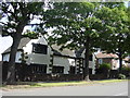
3
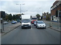
West Derby Road
Traffic heading for the city centre waits at the Green Lane lights.
Image: © Colin Pyle
Taken: 15 Oct 2009
0.08 miles
4
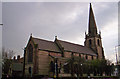
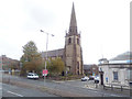
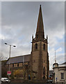
St John the Baptist, Tuebrook
1871. Architect G.F. Bodley. A Grade 1 listed church.
Image: © S Parish
Taken: 24 Mar 2007
0.14 miles
5
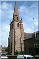
St John the Baptist, Tuebrook, Liverpool
Opened in 1870, this Anglican parish church is grade 1 listed as "A fine example of Bodley's early work with a remarkably complete interior, one of the finest examples of Victorian polychromy."
Image: © Stephen Craven
Taken: 4 Nov 2017
0.14 miles
6
St John the Baptist, Tuebrook, Liverpool
Image: © Dave Kelly
Taken: 26 May 2001
0.14 miles
7
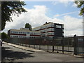
Liverpool Community College
This is the former Millbank College of Commerce which stands on Bankfield Road, Tuebrook.
Image: © Sue Adair
Taken: 14 Aug 2005
0.15 miles
8
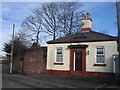
Bankfield House Lodge, Bankfield Rd
This is the lodge for Bankfield House which was demolished, the land was later occupied by West Derby Comprehensive School opened in 1957 as Bankfiled County Secondary Boys School. The school moved to new premises in 2010 and the land was acquired as a new park. The car park adjacent to the new Bankfield Park is on the footprint of the original building.
Image: © Sue Adair
Taken: 4 Mar 2017
0.15 miles
9
St John the Baptist C of E Church, Tuebrook
Image: © Ian Greig
Taken: 19 Dec 2014
0.15 miles
10
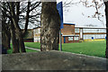
Lister Drive School
This is the new Lister Drive School which is actually in Green Lane.
Image: © stan benbow
Taken: Unknown
0.16 miles