IMAGES TAKEN NEAR TO
Moscow Drive, LIVERPOOL, L13 7DJ
Introduction
This page details the photographs taken nearby to Moscow Drive, L13 7DJ by members of the Geograph project.
The Geograph project started in 2005 with the aim of publishing, organising and preserving representative images for every square kilometre of Great Britain, Ireland and the Isle of Man.

There are currently over 7.5m images from over14,400 individuals and you can help contribute to the project by visiting https://www.geograph.org.uk
Image Map
Images are licensed for reuse under creativecommons.org/licenses/by-sa/2.0
Notes
- Clicking on the map will re-center to the selected point.
- The higher the marker number, the further away the image location is from the centre of the postcode.
Image Listing (12 Images Found)
Images are licensed for reuse under creativecommons.org/licenses/by-sa/2.0
Image
Details
Distance
2
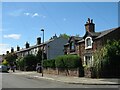
Quarry Road Stoneycroft
The 19th century house on the right stood on the corner of the access to Millbank Quarry which supplied red sandstone for the impressive nearby residences of Sandfield Park. The quarry has recently been covered over and is now a residential road.
Image: © Sue Adair
Taken: 5 Jun 2021
0.17 miles
3
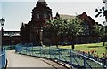
Carnegie library
Carnegie library is at the corner of Green Lane and Lister Drive.
Image: © stan benbow
Taken: Unknown
0.20 miles
4
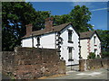
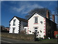
Cottages in Quarry Road
Red sandstone cottages in Quarry Road which were adjacent to Millbank Quarry.
Image: © Sue Adair
Taken: 5 Jun 2021
0.20 miles
5
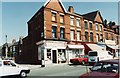
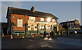
Shops in Green Lane
Shops in Green Lane at the corner of Russian Drive.
Image: © stan benbow
Taken: Unknown
0.20 miles
6
Cottages, Quarry Rd
Brick built cottages with sandstone facing in Quarry Rd adjacent to Millbank Quarry. This quarry provided red sandstone as building material for many of the large houses in West Derby.
Image: © Sue Adair
Taken: 4 Mar 2017
0.20 miles
7
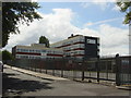
Liverpool Community College
This is the former Millbank College of Commerce which stands on Bankfield Road, Tuebrook.
Image: © Sue Adair
Taken: 14 Aug 2005
0.21 miles
8
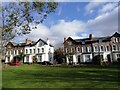
Derwent Square Stoneycroft
The elegant houses of Derwent Square, Derwent Road off Green Lane. This 1860's development was designed to emulate the fashionable Bloomsbury Square in London.
Image: © Sue Adair
Taken: 18 Feb 2021
0.23 miles
9
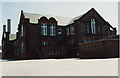
Lister Drive School (2003)
The school has since been demolished.
Image: © stan benbow
Taken: Unknown
0.23 miles
10
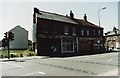
Bomb site
Site was bombed in 1941. Two shops destroyed 61 years later.
Preparation underway for building.
Image: © stan benbow
Taken: 9 Apr 2003
0.23 miles