IMAGES TAKEN NEAR TO
Anstey Road, LIVERPOOL, L13 5UP
Introduction
This page details the photographs taken nearby to Anstey Road, L13 5UP by members of the Geograph project.
The Geograph project started in 2005 with the aim of publishing, organising and preserving representative images for every square kilometre of Great Britain, Ireland and the Isle of Man.

There are currently over 7.5m images from over14,400 individuals and you can help contribute to the project by visiting https://www.geograph.org.uk
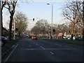
Image Map
Images are licensed for reuse under creativecommons.org/licenses/by-sa/2.0
Notes
- Clicking on the map will re-center to the selected point.
- The higher the marker number, the further away the image location is from the centre of the postcode.
Image Listing (23 Images Found)
Images are licensed for reuse under creativecommons.org/licenses/by-sa/2.0
Image
Details
Distance
1
Queens Drive approaching Oakhill Road
Oakhill Road no longer has direct access to Queens Drive ahead. Its position remains marked by a narrow "U-turn" access still in Queens Drive's central reservation, just beyond the pedestrian crossing lights.
Image: © Peter Whatley
Taken: 17 Jan 2012
0.07 miles
2
A bus on the way to Liverpool Airport passing Broadgreen Hospital
Image: © Ian Greig
Taken: 5 Dec 2014
0.16 miles
3
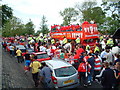
Queens Drive near flyover at Broadgreen.
Procession sets of for tour of the city.
Image: © Colin Pyle
Taken: 26 May 2005
0.17 miles
4
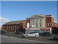
Former Regent Cinema and St Brendan's Church
The former Regent Cinema and St Brendan's Church in Prescot Road, Old Swan. The Regent cinema was independently owned by Wilkinson's funeral directors. In 1926 Robert Wilkinson formed the Regent Cinema Company and the cinema opened later that year. In later years it was used as a supermarket and is now disused. St Brendan's RC church, quite an unremarkable building, stands next door.
Image: © Sue Adair
Taken: 17 Apr 2008
0.18 miles
5
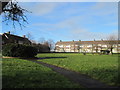
The Green, Broadgreen
The Green and adjacent flats built in the early 1950's. It was on the nearby green on the night of 3rd May 1941 that people made their way to The Rocket air raid shelter during a heavy bombing raid. The shelter took a direct hit leaving many dead and injured, the names of 29 of the victims, many of them children and young people, are on the website below.
http://liverpoolremembrance.weebly.com/rocket-shelter.html
Image: © Sue Adair
Taken: 10 Jan 2018
0.18 miles
6
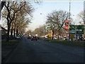
Queens Drive approaching Prescot Road junction
Broad dual carriageways with wide, tree-lined central reservations are characteristic of Liverpool's outer suburbs of the 1920s and 1930s.
Image: © Peter Whatley
Taken: 17 Jan 2012
0.19 miles
7
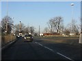
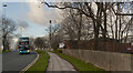
Joining Queens Drive, Stoneycroft
The slip road from Roby Road and Edge Lane joins the flyover portion of Queens Drive.
Image: © Peter Whatley
Taken: 17 Jan 2012
0.19 miles
8
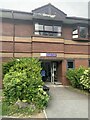
The entrance (and exit) to Maple Suite Liverpool Heart and Chest Hospital
A fond farewell after 10 days and nights board and lodging.
Image: © Richard Hoare
Taken: 31 Jul 2024
0.20 miles
9
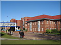
Alexander Wing, Broadgreen Hospital
Alexander Wing is the out-patients clinic building for Broadgreen at the rear of the old hospital which was originally built as a sanatorium.
Image: © Sue Adair
Taken: 14 Feb 2007
0.20 miles
10
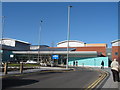
New Entrance, Broadgreen Hospital
The new entrance to Broadgreen Hospital opened in 2006, situated at the rear of the site, a bit of a walk for those with disabilities.
Image: © Sue Adair
Taken: 14 Feb 2007
0.20 miles