IMAGES TAKEN NEAR TO
Whitehouse Road, LIVERPOOL, L13 4DA
Introduction
This page details the photographs taken nearby to Whitehouse Road, L13 4DA by members of the Geograph project.
The Geograph project started in 2005 with the aim of publishing, organising and preserving representative images for every square kilometre of Great Britain, Ireland and the Isle of Man.

There are currently over 7.5m images from over14,400 individuals and you can help contribute to the project by visiting https://www.geograph.org.uk
Image Map
Images are licensed for reuse under creativecommons.org/licenses/by-sa/2.0
Notes
- Clicking on the map will re-center to the selected point.
- The higher the marker number, the further away the image location is from the centre of the postcode.
Image Listing (23 Images Found)
Images are licensed for reuse under creativecommons.org/licenses/by-sa/2.0
Image
Details
Distance
1
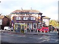
The Gardeners Arms on Broadgreen Road
Image: © Raymond Knapman
Taken: 19 Oct 2010
0.06 miles
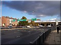
2
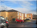
Care home on site of The Gardeners Arms
The Gardeners Arms public house was situated at the bottom of Broad Green Road, there had been an inn at this location since the 1800's. The original inn was at the end of a terrace called "Fairview Cottages". Long before the building of Edge Lane Drive when Broad Green Road (originally called Petticoat Lane) went from Old Swan, past The Rocket Inn, all the way to Roby, there was a huge nursery at Oak Vale. The Gardener's Arms faced the nursery, hence the name. The pub was rebuilt with a bowling green around the 1920's and demolished in 2013 to make way for this care home. Photo of the Gardeners in 2010 http://www.geograph.org.uk/photo/2120720
Image: © Sue Adair
Taken: 10 Jan 2018
0.08 miles
4
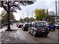
City bound traffic on Edge Lane
Always busy as traffic from the M62 is funnelled onto this city bound route
Image: © Raymond Knapman
Taken: 19 Oct 2010
0.09 miles
6

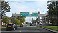
Overhead Sign Gantry on the A5080 at Broad Green
Dual carriageway leading to the M62 out of Liverpool.
Image: © David Dixon
Taken: 11 May 2016
0.11 miles
7
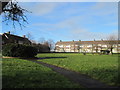
The Green, Broadgreen
The Green and adjacent flats built in the early 1950's. It was on the nearby green on the night of 3rd May 1941 that people made their way to The Rocket air raid shelter during a heavy bombing raid. The shelter took a direct hit leaving many dead and injured, the names of 29 of the victims, many of them children and young people, are on the website below.
http://liverpoolremembrance.weebly.com/rocket-shelter.html
Image: © Sue Adair
Taken: 10 Jan 2018
0.12 miles
8
Heavy clouds form over road sign gantry at the Rocket
The M62 begins just beyond the Queens Drive flyover where the Rocket pub is located
Image: © Raymond Knapman
Taken: 19 Oct 2010
0.13 miles
9

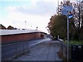
A5080 at Broad Green
Dual carriageway leading to the M62 out of Liverpool.
Image: © David Dixon
Taken: 11 May 2016
0.14 miles
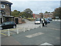
10
Cycle route signage next to Queens Drive flyover
Image: © Raymond Knapman
Taken: 19 Oct 2010
0.15 miles