IMAGES TAKEN NEAR TO
Leveson Road, LIVERPOOL, L13 4AU
Introduction
This page details the photographs taken nearby to Leveson Road, L13 4AU by members of the Geograph project.
The Geograph project started in 2005 with the aim of publishing, organising and preserving representative images for every square kilometre of Great Britain, Ireland and the Isle of Man.

There are currently over 7.5m images from over14,400 individuals and you can help contribute to the project by visiting https://www.geograph.org.uk
Image Map
Images are licensed for reuse under creativecommons.org/licenses/by-sa/2.0
Notes
- Clicking on the map will re-center to the selected point.
- The higher the marker number, the further away the image location is from the centre of the postcode.
Image Listing (17 Images Found)
Images are licensed for reuse under creativecommons.org/licenses/by-sa/2.0
Image
Details
Distance
1
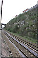
Charter train passes through Olive Mount Cutting
UK Railtours charter 'Olive Branch 2' passes through the cutting heading for Broad Green station.
Image: © Roger Templeman
Taken: 14 Apr 2012
0.10 miles
3
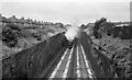
The Fifteen Guinea Special in Olive Mount Cutting ? 1968
This was the very last standard gauge steam passenger train operated by British Rail, on 11 August 1968, regular steam services having ended the previous weekend. The named was coined to reflect the cost of a ticket for the journey.
The train ran from Liverpool to Carlisle and return, travelling via Manchester, Blackburn and the Settle and Carlisle line. Between Liverpool and Manchester it was hauled by Stanier 'Black 5' 4-6-0 locomotive 45110, seen here passing through the iconic Olive Mount cutting on the outskirts of Liverpool. This was one of the major engineering works of the original Liverpool and Manchester of 1830, and would be no mean feat even in the 21st century. The relatively soft and homogeneous Bunter Sandstone meant that the cutting could be excavate with vertical sides which adds to the impressiveness.
Image: © Alan Murray-Rust
Taken: 11 Aug 1968
0.11 miles
4
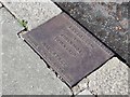
Old Boundary Marker
Parish Boundary Marker on the south side of the A5080 Edge Hill Drive, set in the kerb outside number 110. Liverpool metropolitan district. In raised lettering TOWNSHIP / OF / WEST DERBY / ERECTED BY THE OVERSEERS 1868 (facing south) and TOWNSHIP / OF / WAVERTREE / ERECTED BY THE OVERSEERS 1868 (facing north). On the former boundary of West Derby and Wavertree townships. Reference http://www.liverpool.ndo.co.uk/wavsoc/news18/page27.html.
Milestone Society National ID: LA_LVWVWD02pb
Image: © M Chitty, Wavertree Society
Taken: 1 Feb 2019
0.12 miles
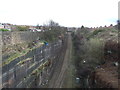
6
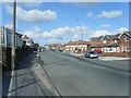
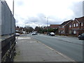
Mill Lane, Wavertree.
Looking north from a point on the bridge across Olive Mount Cutting.
Image: © Colin Pyle
Taken: 8 Oct 2009
0.15 miles
7
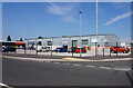
Northway Shops
Once a busy row of shops in Northway, other than a small convenience store, you would be hard pushed to find anywhere here to buy your weekly shopping nowadays.
Image: © Sue Adair
Taken: 14 Apr 2008
0.15 miles
10
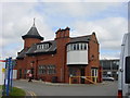
Rathbone Hospital, Liverpool
Situated in Mill Lane, Wavertree now houses the Department of Psychology, Mersey Care NHS Trust.
Image: © Sue Adair
Taken: 15 Aug 2005
0.18 miles