IMAGES TAKEN NEAR TO
Bibby Street, LIVERPOOL, L13 2DX
Introduction
This page details the photographs taken nearby to Bibby Street, L13 2DX by members of the Geograph project.
The Geograph project started in 2005 with the aim of publishing, organising and preserving representative images for every square kilometre of Great Britain, Ireland and the Isle of Man.

There are currently over 7.5m images from over14,400 individuals and you can help contribute to the project by visiting https://www.geograph.org.uk
Image Map
Images are licensed for reuse under creativecommons.org/licenses/by-sa/2.0
Notes
- Clicking on the map will re-center to the selected point.
- The higher the marker number, the further away the image location is from the centre of the postcode.
Image Listing (20 Images Found)
Images are licensed for reuse under creativecommons.org/licenses/by-sa/2.0
Image
Details
Distance
1
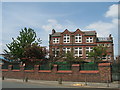
St. Anne's (Stanley) C of E Primary School
Image: © Sue Adair
Taken: 24 May 2008
0.09 miles
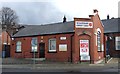
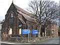
3
Stoneycroft Salvation Army Church and Centre
Stoneycroft Salvation Army Church and centre in Prescot Road, Old Swan built about a hundred years ago.
Image: © Sue Adair
Taken: 17 Apr 2008
0.13 miles
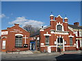
4
Stoneycroft Methodist Church
Stoneycroft Methodist Church in Greenfield Road, Old Swan was founded in 1865.
Image: © Sue Adair
Taken: 17 Apr 2008
0.13 miles
5
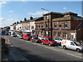
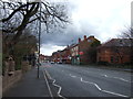
Prescot Road, Old Swan
Prescot Road, Old Swan, looking west towards Liverpool, still looking pretty much the same. The sandstone building is the Nat West bank and the white one at the end of the block is Edwards the jewellers established almost a hundred years ago, outside of which still hangs three brass balls.
Image: © Sue Adair
Taken: 17 Apr 2008
0.14 miles
7
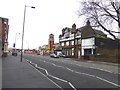
The derelict Stanley pub on Prescot Road
The Stanley Fish and Meat Market seen in the distance.
Image: © Raymond Knapman
Taken: 18 Feb 2014
0.15 miles
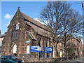
10
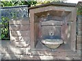
Melly Drinking Fountain
Drinking fountain of polished red Aberdeen granite set into the wall of St Anne's church, Stanley and provided by cotton merchant and philanthropist Charles Pierre Melly. He was born in Tuebrook on 25th May 1829 and came up with the idea for public drinking fountains during a visit to his father's birthplace of Geneva, Switzerland in 1852. He erected the first in 1854 and many more around the city in the following years, these fountains provided fresh water for working class people at a time when pure drinking water was almost unavailable. Many are still in existence in Liverpool, this one originally would have had a brass tiger head water spout.
http://www.liverpoolmonuments.co.uk/drinking/mellycharles02.html
Image: © Sue Adair
Taken: 27 May 2021
0.18 miles