IMAGES TAKEN NEAR TO
Elms House Road, LIVERPOOL, L13 2BW
Introduction
This page details the photographs taken nearby to Elms House Road, L13 2BW by members of the Geograph project.
The Geograph project started in 2005 with the aim of publishing, organising and preserving representative images for every square kilometre of Great Britain, Ireland and the Isle of Man.

There are currently over 7.5m images from over14,400 individuals and you can help contribute to the project by visiting https://www.geograph.org.uk
Image Map
Images are licensed for reuse under creativecommons.org/licenses/by-sa/2.0
Notes
- Clicking on the map will re-center to the selected point.
- The higher the marker number, the further away the image location is from the centre of the postcode.
Image Listing (21 Images Found)
Images are licensed for reuse under creativecommons.org/licenses/by-sa/2.0
Image
Details
Distance
3
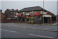
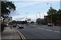
Brambles Public House
On St Oswalds Street, Liverpool.
Image: © Ian S
Taken: 10 Jun 2019
0.16 miles
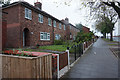
5
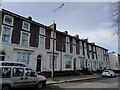
Buxton Terrace, Mill Lane
A mid 18th century terrace near the junction of Mill Lane with St. Oswald Street.
Image: © Sue Adair
Taken: 11 Mar 2021
0.18 miles
6
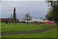
Small park by Edge Lane
Looking down towards Edge Lane Retail Park. In the far distance is the tower of the Anglican cathedral.
Image: © Bill Boaden
Taken: 19 Oct 2013
0.19 miles
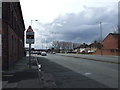
8
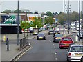
Rathbone Road approaching Edge Lane
Edge Lane is the main route between the M62 and Liverpool city centre, and is consequently quite busy.
Image: © Bill Boaden
Taken: 19 Oct 2013
0.20 miles
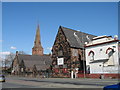
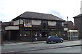
10
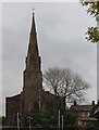
St Oswald's King and Martyr Catholic Church
Image: © Ian Greig
Taken: 14 Dec 2014
0.20 miles