IMAGES TAKEN NEAR TO
Packenham Road, LIVERPOOL, L13 0DA
Introduction
This page details the photographs taken nearby to Packenham Road, L13 0DA by members of the Geograph project.
The Geograph project started in 2005 with the aim of publishing, organising and preserving representative images for every square kilometre of Great Britain, Ireland and the Isle of Man.

There are currently over 7.5m images from over14,400 individuals and you can help contribute to the project by visiting https://www.geograph.org.uk
Image Map
Images are licensed for reuse under creativecommons.org/licenses/by-sa/2.0
Notes
- Clicking on the map will re-center to the selected point.
- The higher the marker number, the further away the image location is from the centre of the postcode.
Image Listing (11 Images Found)
Images are licensed for reuse under creativecommons.org/licenses/by-sa/2.0
Image
Details
Distance
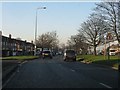
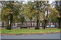
4
Queens Drive north of Mill Bank junction
Image: © Peter Whatley
Taken: 17 Jan 2012
0.11 miles
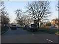
5
Muirhead Avenue south of Queen's Drive, Liverpool
The wide avenues of suburban Liverpool were built to accommodate cars and trams.
Image: © Mike Pennington
Taken: 22 Oct 2015
0.15 miles
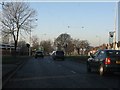
7
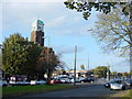
Junction of Queens Drive and Townsend Lane
The busy junction of Queens Drive (A5080) and Townsend Lane (A580) showing the lofty tower of St Matthew's church and opposite, a former bank, now an undertakers.
Image: © Sue Adair
Taken: 31 Oct 2005
0.16 miles
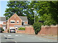
8
Bankfield House Lodge, Bankfield Rd
This is the lodge for Bankfield House which was demolished, the land was later occupied by West Derby Comprehensive School opened in 1957 as Bankfiled County Secondary Boys School. The school moved to new premises in 2010 and the land was acquired as a new park. The car park adjacent to the new Bankfield Park is on the footprint of the original building.
Image: © Sue Adair
Taken: 4 Mar 2017
0.17 miles
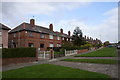
9
Holly Lodge Girls School
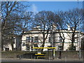
The former Holly Lodge Girls School started out in 1828 as a private residence and later with other buildings added in the grounds became a school for girls which was opened in 1922. It closed in 2015 and although used as a film set for a short time, was demolished for new housing in the following year.
Image: © Sue Adair
Taken: 10 Feb 2010
0.19 miles
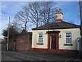
10
Church of the Latter Day Saints
An unusual use of stained glass in a modern church.This church stands in Millbank, Tuebrook.
Image: © Sue Adair
Taken: 14 Aug 2005
0.23 miles