1
Liverpool: 4-6, Rodney Street
Image: © Michael Garlick
Taken: 30 Apr 2024
0.00 miles
2
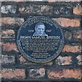
Liverpool, 4 Rodney Street: Plaque commemorating the birth of Brian Epstein, the Beatles' manager
Image: © Michael Garlick
Taken: 30 Apr 2024
0.01 miles
3
Detail of 2 Rodney Street, Liverpool
Fine doorcase of particularly broad proportions, the door framed by fluted Ionic columns and a large plain arched fanlight.
Image: © Stephen Richards
Taken: 12 Jun 2015
0.02 miles
4
Rodney Street, Liverpool
This area of eighteenth-century houses is now branded as Liverpool's Georgian Quarter.
Rodney Street, like many Liverpool locations, features in a pop song: in this case "Camera Camera" by The Teardrop Explodes.
Image: © Christopher Hilton
Taken: 11 Aug 2022
0.02 miles
5
Rodney Street, Liverpool
In the distance, Liverpool's Anglican Cathedral; the Roman Catholic Cathedral is close by, behind the photographer's back.
This area of eighteenth-century houses is now branded as Liverpool's Georgian Quarter.
Rodney Street, like many Liverpool locations, features in a pop song: in this case "Camera Camera" by The Teardrop Explodes.
Image: © Christopher Hilton
Taken: 11 Aug 2022
0.02 miles
6
Rodney Street, Liverpool
Looking south along the west side of what must be one of the best Georgian streets in the country. This picture illustrates Pevsner's comment that it is "all the more enjoyable for the constant fidgeting of the building lines". An early development in the city, it was laid out in 1783-84 by William Roscoe and others.
Image: © Stephen Richards
Taken: 12 Jun 2015
0.02 miles
7
Maryland Street
This is the Hope Street end of Maryland Street, Liverpool 3, with Rodney Street at the far end. The two-storey building further along on the left used to be the refectory of Notre Dame College of Education; this building is now the Liverpool John Moores University (JMU) Students' Union. The buildings to the right (off photo), also part of the JMU estate, once housed the teaching spaces and administration offices of Notre Dame College Education.
Image: © Carroll Pierce
Taken: 8 Jul 2013
0.03 miles
8
MacKenzie's Tomb
William MacKenzie was a British civil engineer and civil engineering contractor who was one of the leading European contractors in the 1840s. He was buried at St Andrew's church in 1851 and in 1868 his brother Edward erected this pyramid-shaped monument over his grave.
Local folklore has it that MacKenzie was entombed seated at a table with a winning hand of cards in his bony fingers. As an inveterate gambler, it is said that he bet and lost his soul in a game of poker with the Devil. He reasoned that if he was never buried, Satan could not claim his prize. This claim is difficult to substantiate, and may simply be a myth.
Image: © Paul Brooker
Taken: 22 Jan 2014
0.03 miles
9
Detail of 20 Rodney Street, Liverpool
Unusually lofty and slender Georgian doorcase, almost a porch. The Ionic columns are extraordinarily tall.
Image: © Stephen Richards
Taken: 12 Jun 2015
0.03 miles
10
Roscoe Street, Liverpool
Image: © Ian S
Taken: 12 Jun 2019
0.03 miles


