IMAGES TAKEN NEAR TO
Almonds Grove, LIVERPOOL, L12 5HU
Introduction
This page details the photographs taken nearby to Almonds Grove, L12 5HU by members of the Geograph project.
The Geograph project started in 2005 with the aim of publishing, organising and preserving representative images for every square kilometre of Great Britain, Ireland and the Isle of Man.

There are currently over 7.5m images from over14,400 individuals and you can help contribute to the project by visiting https://www.geograph.org.uk
Image Map
Images are licensed for reuse under creativecommons.org/licenses/by-sa/2.0
Notes
- Clicking on the map will re-center to the selected point.
- The higher the marker number, the further away the image location is from the centre of the postcode.
Image Listing (15 Images Found)
Images are licensed for reuse under creativecommons.org/licenses/by-sa/2.0
Image
Details
Distance
1
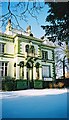
Lowlands, West Derby Community Association
This Grade II-listed former merchant's mansion built in 1846 has been home of the West Derby Community Association since 1957. In the early 1960s it was the home of the Pillar Club where many famous musicians, including the early Beatles, played.
Image: © Stephen Guy
Taken: 26 Dec 2002
0.02 miles
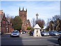
3
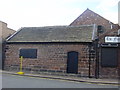
Old Wapentake Court, West Derby
There are still many old buildings in West Derby, this is the old manor court house, Wapentake means "weapon touch" when the Sergeant of the Hundred held his court, he would stick his spear into the ground and the liege men would touch with their swords as a sign of fealty. King John transferred the Wapentake court from West Derby in 1207, when he granted his Charter to Liverpool.
Image: © Sue Adair
Taken: 14 Aug 2005
0.15 miles
4
St Mary's primary school, West Derby
Situated right beside St Mary's parish church, West Derby, this old sandstone building has been sympathetically extended.
Image: © Sue Adair
Taken: 14 Aug 2005
0.15 miles
5
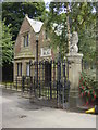
Gatehouse, Croxteth Park
This is the West Derby gatehouse on the main drive to Croxteth Hall. It is situated next to St Mary's Church, West Derby. Croxteth Hall and Park have been open to the public since 1976.
Image: © Sue Adair
Taken: 14 Aug 2005
0.15 miles
6
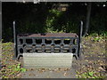
West Derby Village Stocks
Originally situated next to the Courthouse, West Derby Village stocks are now located in the pinfold at the top of Meadow Lane. Belonging to the Duke of Lancaster, this was an enclosure where stray cattle, pigs and other animals were impounded until claimed by their owners on payment of a fine. The original stocks, made of wood, eventually rotted and the replacement stocks, made from iron are the ones that remain today. They were placed in their current position to commemorate the coronation of Edward VII in 1902.
Image: © Sue Adair
Taken: 14 Aug 2005
0.15 miles
8
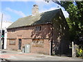
Yeoman's House, West Derby
The ‘Yeoman’s House’ is thought to date from the 1580's, similar to the historic courthouse across the road.
Internal photographs on this website https://historic-liverpool.co.uk/yeomans-house-west-derby/
Image: © Sue Adair
Taken: 14 Aug 2005
0.16 miles
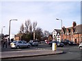
9
The water fountain in West Derby Village
The inscription reads "Water is best"
Image: © Raymond Knapman
Taken: 8 Feb 2011
0.17 miles
10
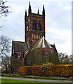
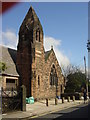
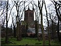
The Parish Church of St Mary, West Derby
Image: © Ian Greig
Taken: 22 Nov 2014
0.17 miles