IMAGES TAKEN NEAR TO
Town Row, LIVERPOOL, L12 5HG
Introduction
This page details the photographs taken nearby to Town Row, L12 5HG by members of the Geograph project.
The Geograph project started in 2005 with the aim of publishing, organising and preserving representative images for every square kilometre of Great Britain, Ireland and the Isle of Man.

There are currently over 7.5m images from over14,400 individuals and you can help contribute to the project by visiting https://www.geograph.org.uk
Image Map
Images are licensed for reuse under creativecommons.org/licenses/by-sa/2.0
Notes
- Clicking on the map will re-center to the selected point.
- The higher the marker number, the further away the image location is from the centre of the postcode.
Image Listing (20 Images Found)
Images are licensed for reuse under creativecommons.org/licenses/by-sa/2.0
Image
Details
Distance
1

Houses on Town Row, West Derby
A couple of surviving older houses among the 20th century semis which now dominate the road.
Image: © Paul Harrop
Taken: 11 Aug 2013
0.05 miles
2
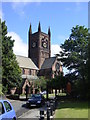
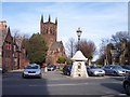
St Mary's Church, West Derby
West Derby's present parish church, built in 1853/4 to the design of Gilbert G. Scott, took the place of the ancient Chapel of St Mary the Virgin which stood in the village centre. The Heywood Monument marks its altar site.
Image: © Sue Adair
Taken: 14 Aug 2005
0.13 miles
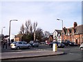
5
The water fountain in West Derby Village
The inscription reads "Water is best"
Image: © Raymond Knapman
Taken: 8 Feb 2011
0.14 miles
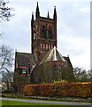
6
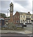
West Derby monument
This village cross stands at the site of the former chapel. Designed by Eden Nesfield 1861-70 in the Gothic style, it features a seated figure of Christ on a shaft of five columns.
Image: © Paul Harrop
Taken: 11 Aug 2013
0.15 miles
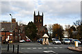
7
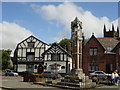
Village centre, West Derby
As one of the eight hundreds of Lancashire, West Derby was far more important than the little hamlet of Liverpool. The name Derby means good hunting place and at the time of the Danish settlers there was a huge forest here. A Saxon fort stood here for 200 years, followed by a Norman castle which was held by Richard I in 1197, holding a garrison of 10 knights and crossbowmen and 140 foot soldiers. The castle was allowed to decay when Liverpool's fortress was built and now only a garden marks its position.
Image: © Sue Adair
Taken: 14 Aug 2005
0.15 miles
9
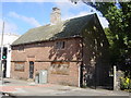
Yeoman's House, West Derby
The ‘Yeoman’s House’ is thought to date from the 1580's, similar to the historic courthouse across the road.
Internal photographs on this website https://historic-liverpool.co.uk/yeomans-house-west-derby/
Image: © Sue Adair
Taken: 14 Aug 2005
0.16 miles