IMAGES TAKEN NEAR TO
Sergeant Road, LIVERPOOL, L12 4WT
Introduction
This page details the photographs taken nearby to Sergeant Road, L12 4WT by members of the Geograph project.
The Geograph project started in 2005 with the aim of publishing, organising and preserving representative images for every square kilometre of Great Britain, Ireland and the Isle of Man.

There are currently over 7.5m images from over14,400 individuals and you can help contribute to the project by visiting https://www.geograph.org.uk
Image Map
Images are licensed for reuse under creativecommons.org/licenses/by-sa/2.0
Notes
- Clicking on the map will re-center to the selected point.
- The higher the marker number, the further away the image location is from the centre of the postcode.
Image Listing (7 Images Found)
Images are licensed for reuse under creativecommons.org/licenses/by-sa/2.0
Image
Details
Distance
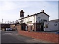
1
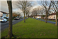
Princess Drive
These broad boulevards are so typical of Liverpool. This is a legacy of large parts of the city being built around a tram network.
Image: © Ian Greig
Taken: 22 Nov 2014
0.13 miles
2
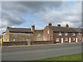
Elm Cottage and Ash Terrace
Elm Cottage and Ash Terrace on Deysbrook Lane, built early 18th century. One of the original lanes leading from West Derby Village to Croxteth Hall, these cottages would have housed workers on the estate.
Image: © Sue Adair
Taken: 24 Mar 2018
0.13 miles
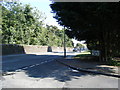
3
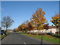
Princess Drive
Princess Drive looking towards the junction with Deysbrook Lane.
Image: © Sue Adair
Taken: 6 Nov 2007
0.13 miles
4
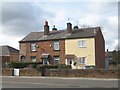
19-21 Ash Terrace, Deysbrook Lane
18th Century cottages adjacent to Deysbrook Farm (now the site of The Deysbrook public house). Corporal H Lawrenson Aged 22 of The King's Liverpool Regiment, son of Mrs. E. Lawrenson of 19 Ash Terrace, Deysbrook Lane was killed at Ypres in 1915.
Image: © Sue Adair
Taken: 24 Mar 2018
0.15 miles
7
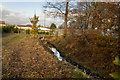
A tributary of the River Alt
The brook disappears underground here to re-appear in a kilometre away in Croxteth Park
Image: © Ian Greig
Taken: 22 Nov 2014
0.23 miles