IMAGES TAKEN NEAR TO
Storrington Avenue, LIVERPOOL, L11 9AU
Introduction
This page details the photographs taken nearby to Storrington Avenue, L11 9AU by members of the Geograph project.
The Geograph project started in 2005 with the aim of publishing, organising and preserving representative images for every square kilometre of Great Britain, Ireland and the Isle of Man.

There are currently over 7.5m images from over14,400 individuals and you can help contribute to the project by visiting https://www.geograph.org.uk
Image Map
Images are licensed for reuse under creativecommons.org/licenses/by-sa/2.0
Notes
- Clicking on the map will re-center to the selected point.
- The higher the marker number, the further away the image location is from the centre of the postcode.
Image Listing (5 Images Found)
Images are licensed for reuse under creativecommons.org/licenses/by-sa/2.0
Image
Details
Distance
1
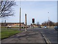
Old sewage pipe vent on Stonebridge Lane
This relic from the past is at the junction with Storrington avenue
Image: © Raymond Knapman
Taken: 8 Feb 2011
0.09 miles
2
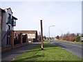
Old sewage pipe vent on Stonebridge Lane
These old vents may be found all around Liverpool streets
Image: © Raymond Knapman
Taken: 8 Feb 2011
0.20 miles
4
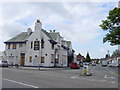
Dog and Gun Pub and Carr Lane East, Croxteth
The derelict Dog and Gun public house at the junction of Carr Lane East with Stonebridge Lane, Croxteth. The area took its name from the 19th century inn.
Image: © Sue Adair
Taken: 1 Jun 2006
0.22 miles
5
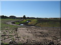
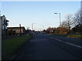
New course for River Alt
The River Alt has been taken out of its 300m culvert and now meanders through a newly constructed riverside park. The original re-routing suggestion was discussed when Amazon were considering building a huge warehouse on the adjacent site.
https://www.facebook.com/RiverAltproject
Image: © Sue Adair
Taken: 5 Jul 2014
0.25 miles