IMAGES TAKEN NEAR TO
Fieldton Road, LIVERPOOL, L11 9AE
Introduction
This page details the photographs taken nearby to Fieldton Road, L11 9AE by members of the Geograph project.
The Geograph project started in 2005 with the aim of publishing, organising and preserving representative images for every square kilometre of Great Britain, Ireland and the Isle of Man.

There are currently over 7.5m images from over14,400 individuals and you can help contribute to the project by visiting https://www.geograph.org.uk
Image Map
Images are licensed for reuse under creativecommons.org/licenses/by-sa/2.0
Notes
- Clicking on the map will re-center to the selected point.
- The higher the marker number, the further away the image location is from the centre of the postcode.
Image Listing (8 Images Found)
Images are licensed for reuse under creativecommons.org/licenses/by-sa/2.0
Image
Details
Distance
1
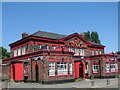
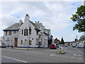
The Sefton Arms Hotel
The Sefton Arms in Carr Lane East, built in rural West Derby at the end of the 19th century, long before the construction of the Croxteth housing estate. The public house was constructed along with twelve adjacent cottages and a schoolhouse which have now been demolished.
Image: © Sue Adair
Taken: 29 May 2018
0.07 miles
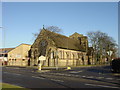
2
The Good Shepherd Church and Community Centre, Carr Lane East
Image: © Ian Greig
Taken: 14 Nov 2014
0.13 miles
3
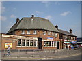
The Western Approaches
The Western Approaches public house at the corner of Lowerhouse Lane and Storrington Avenue.
Image: © Sue Adair
Taken: 25 May 2010
0.15 miles
4
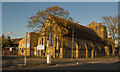
Church of the Good Shepherd, West Derby
The Church of the Good Shepherd, West Derby is at the junction of two ancient lanes, Dwerryhouse Lane and Carr Lane East. John Davies is the present curate, he has some amusing reflections and local walks on his website: http://www.johndavies.org/jd-ME.html
Image: © Sue Adair
Taken: 14 Jan 2006
0.17 miles
5
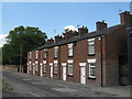
Charnock Cottages, Lower House Lane
Backing on to the Fire Station, Charnock Cottages stood in the middle of Lower House Lane long before the existence of Storrington Avenue. The Lower House was nearby, adjacent to impressive lodge at West Derby Cemetery gates.
Image: © Sue Adair
Taken: 13 Jun 2020
0.21 miles
6
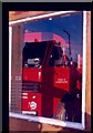
Reflections of Fire
This image was taken of the firestation at the top of storrington avenue circa april 1985.
Image: © Rob Rylands
Taken: 12 Apr 1985
0.21 miles
8
Dog and Gun Pub and Carr Lane East, Croxteth
The derelict Dog and Gun public house at the junction of Carr Lane East with Stonebridge Lane, Croxteth. The area took its name from the 19th century inn.
Image: © Sue Adair
Taken: 1 Jun 2006
0.22 miles