IMAGES TAKEN NEAR TO
Sedgemoor Road, LIVERPOOL, L11 3BR
Introduction
This page details the photographs taken nearby to Sedgemoor Road, L11 3BR by members of the Geograph project.
The Geograph project started in 2005 with the aim of publishing, organising and preserving representative images for every square kilometre of Great Britain, Ireland and the Isle of Man.

There are currently over 7.5m images from over14,400 individuals and you can help contribute to the project by visiting https://www.geograph.org.uk
Image Map
Images are licensed for reuse under creativecommons.org/licenses/by-sa/2.0
Notes
- Clicking on the map will re-center to the selected point.
- The higher the marker number, the further away the image location is from the centre of the postcode.
Image Listing (5 Images Found)
Images are licensed for reuse under creativecommons.org/licenses/by-sa/2.0
Image
Details
Distance
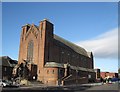
1

Christ Church, Norris Green (demolished)
1932, Architect Quiggin & Gee. The church was demolished in 2006.
Image: © S Parish
Taken: 21 Jul 2006
0.01 miles
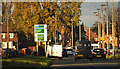
2
Church of St Teresa of the Child Jesus
St Teresa of the Child Jesus at the junction of Utting Avenue East with Sedgemoor Road, Norris Green.
Image: © Sue Adair
Taken: 23 Sep 2009
0.22 miles
3
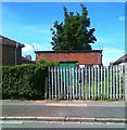
Electricity sub station, Scargreen Avenue
Image: © Alex McGregor
Taken: 14 Jun 2011
0.22 miles
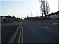
5
Townsend Avenue approaches the East Lancashire Road junction
Image: © Ian Greig
Taken: 14 Nov 2014
0.23 miles