IMAGES TAKEN NEAR TO
Cottesbrook Road, LIVERPOOL, L11 3AF
Introduction
This page details the photographs taken nearby to Cottesbrook Road, L11 3AF by members of the Geograph project.
The Geograph project started in 2005 with the aim of publishing, organising and preserving representative images for every square kilometre of Great Britain, Ireland and the Isle of Man.

There are currently over 7.5m images from over14,400 individuals and you can help contribute to the project by visiting https://www.geograph.org.uk
Image Map
Images are licensed for reuse under creativecommons.org/licenses/by-sa/2.0
Notes
- Clicking on the map will re-center to the selected point.
- The higher the marker number, the further away the image location is from the centre of the postcode.
Image Listing (10 Images Found)
Images are licensed for reuse under creativecommons.org/licenses/by-sa/2.0
Image
Details
Distance
1
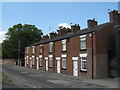
Charnock Cottages, Lower House Lane
Backing on to the Fire Station, Charnock Cottages stood in the middle of Lower House Lane long before the existence of Storrington Avenue. The Lower House was nearby, adjacent to impressive lodge at West Derby Cemetery gates.
Image: © Sue Adair
Taken: 13 Jun 2020
0.13 miles
4
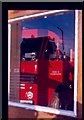
Reflections of Fire
This image was taken of the firestation at the top of storrington avenue circa april 1985.
Image: © Rob Rylands
Taken: 12 Apr 1985
0.16 miles
5
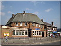
The Western Approaches
The Western Approaches public house at the corner of Lowerhouse Lane and Storrington Avenue.
Image: © Sue Adair
Taken: 25 May 2010
0.18 miles
7
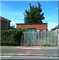
Electricity sub station, Scargreen Avenue
Image: © Alex McGregor
Taken: 14 Jun 2011
0.20 miles
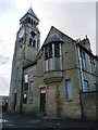
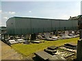
10
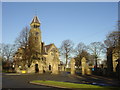
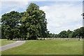
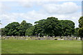
West Derby Cemetery Gatehouse, Lower House Lane
West Derby Cemetery was opened in 1884, Lower House Lane is named after the lone farmhouse which stood nearby.
Image: © Sue Adair
Taken: 14 Jan 2006
0.25 miles