IMAGES TAKEN NEAR TO
Marshfield Road, LIVERPOOL, L11 2TH
Introduction
This page details the photographs taken nearby to Marshfield Road, L11 2TH by members of the Geograph project.
The Geograph project started in 2005 with the aim of publishing, organising and preserving representative images for every square kilometre of Great Britain, Ireland and the Isle of Man.

There are currently over 7.5m images from over14,400 individuals and you can help contribute to the project by visiting https://www.geograph.org.uk
Image Map
Images are licensed for reuse under creativecommons.org/licenses/by-sa/2.0
Notes
- Clicking on the map will re-center to the selected point.
- The higher the marker number, the further away the image location is from the centre of the postcode.
Image Listing (6 Images Found)
Images are licensed for reuse under creativecommons.org/licenses/by-sa/2.0
Image
Details
Distance
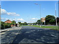
2
Muirhead Avenue East roundabout at entrance to croxteth Park
Image: © Raymond Knapman
Taken: 8 Feb 2011
0.17 miles
3
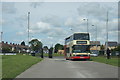
Bus entering Croxteth Country Park
Coming in from Muirhead Avenue East.
Image: © Mike Pennington
Taken: 9 Jul 2015
0.19 miles
4
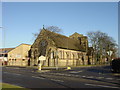
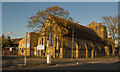
Church of the Good Shepherd, West Derby
The Church of the Good Shepherd, West Derby is at the junction of two ancient lanes, Dwerryhouse Lane and Carr Lane East. John Davies is the present curate, he has some amusing reflections and local walks on his website: http://www.johndavies.org/jd-ME.html
Image: © Sue Adair
Taken: 14 Jan 2006
0.20 miles
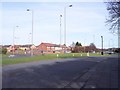
5

Entrance to The Derby Mills on Muirhead Avenue East
Image: © Raymond Knapman
Taken: 8 Feb 2011
0.22 miles
6
The Good Shepherd Church and Community Centre, Carr Lane East
Image: © Ian Greig
Taken: 14 Nov 2014
0.24 miles