IMAGES TAKEN NEAR TO
Montrovia Crescent, LIVERPOOL, L10 9ND
Introduction
This page details the photographs taken nearby to Montrovia Crescent, L10 9ND by members of the Geograph project.
The Geograph project started in 2005 with the aim of publishing, organising and preserving representative images for every square kilometre of Great Britain, Ireland and the Isle of Man.

There are currently over 7.5m images from over14,400 individuals and you can help contribute to the project by visiting https://www.geograph.org.uk
Image Map
Images are licensed for reuse under creativecommons.org/licenses/by-sa/2.0
Notes
- Clicking on the map will re-center to the selected point.
- The higher the marker number, the further away the image location is from the centre of the postcode.
Image Listing (3 Images Found)
Images are licensed for reuse under creativecommons.org/licenses/by-sa/2.0
Image
Details
Distance
1
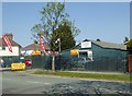
Fazakerley Memorial Hall
Diversifying to add to the coffers - offering significant cut price parking for visitors to the nearby Aintree University Hospital and Walton Centre.
Image: © Eirian Evans
Taken: 9 May 2016
0.18 miles

3
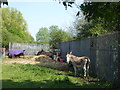
Four donkeys in Fazakerley
In a small pen near Fazakerley Brook.
Image: © Eirian Evans
Taken: 9 May 2016
0.24 miles