IMAGES TAKEN NEAR TO
Maytree Court, LIVERPOOL, L10 4AB
Introduction
This page details the photographs taken nearby to Maytree Court, L10 4AB by members of the Geograph project.
The Geograph project started in 2005 with the aim of publishing, organising and preserving representative images for every square kilometre of Great Britain, Ireland and the Isle of Man.

There are currently over 7.5m images from over14,400 individuals and you can help contribute to the project by visiting https://www.geograph.org.uk
Image Map
Images are licensed for reuse under creativecommons.org/licenses/by-sa/2.0
Notes
- Clicking on the map will re-center to the selected point.
- The higher the marker number, the further away the image location is from the centre of the postcode.
Image Listing (6 Images Found)
Images are licensed for reuse under creativecommons.org/licenses/by-sa/2.0
Image
Details
Distance
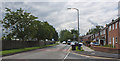
1

Clock House Bridge, Bridge House Lane, Fazakerley
Bridge Marker on Clock House Bridge, Bridge House Lane on the Fazakerley/Kirkby boundary, over Fazakerley Brook.
Inscription reads:-
Clock House Bridge
C.C. 23.
Milestone Society National ID: LA_KIRLIV01br
Image: © John S Turner
Taken: 14 May 2014
0.08 miles
3
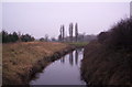
River Alt, Gillmoss
At the border of Liverpool and Knowsley. The river rises in Huyton and runs 28km to the Mersey.
Image: © S Parish
Taken: 2 Feb 2006
0.12 miles
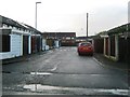
6

The rear of the Veolia waste disposal and recycling plant
Viewed from Electric Avenue across undeveloped industrial land. Front view Image]
Image: © Ian Greig
Taken: 23 Jul 2012
0.25 miles